IMAGES TAKEN NEAR TO
London Road, ST. ALBANS, AL1 1NQ
Introduction
This page details the photographs taken nearby to London Road, AL1 1NQ by members of the Geograph project.
The Geograph project started in 2005 with the aim of publishing, organising and preserving representative images for every square kilometre of Great Britain, Ireland and the Isle of Man.

There are currently over 7.5m images from over14,400 individuals and you can help contribute to the project by visiting https://www.geograph.org.uk
Image Map
Images are licensed for reuse under creativecommons.org/licenses/by-sa/2.0
Notes
- Clicking on the map will re-center to the selected point.
- The higher the marker number, the further away the image location is from the centre of the postcode.
Image Listing (867 Images Found)
Images are licensed for reuse under creativecommons.org/licenses/by-sa/2.0
Image
Details
Distance
1
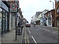
London Road (A1081), St Albans
Looking north west.
Image: © JThomas
Taken: 18 Mar 2017
0.01 miles
2
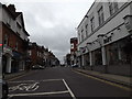
A1081 London Road, St.Albans
At the junction with the A5183 High Street, A5183 Holywell Hill & A1081 Chequer Street
Image: © Geographer
Taken: 9 Nov 2015
0.01 miles
4
Autumn Sunshine in St.Albans
Looking towards the junction of London Road and Holywell Hill.
Image: © Peter Trimming
Taken: 5 Nov 2012
0.01 miles
5
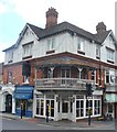
St Albans
Late Victorian (1898) building at the top of Holywell Hill. It has an unusual wooden balcony above the door.
Image: © Colin Smith
Taken: 13 Aug 2016
0.01 miles
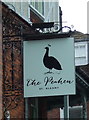
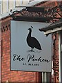
6
The Peahen, St Albans
On London Road (A1081).
Image: © JThomas
Taken: 18 Mar 2017
0.01 miles
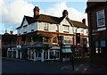
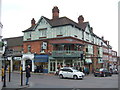
8
The Peahen
Suitably dowdy, especially on a wet December afternoon, The Peahen stands on the corner of London Road and Holywell Hill.
Image: © Martin Addison
Taken: 9 Dec 2007
0.02 miles
9
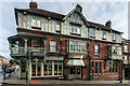
The Peahen
An inn called The Peahen existed at this site in at least the 17th century. However, the current building dates from 1898, when the previous timber framed building was demolished and rebuilt. It is locally listed.
It is situated at what was once one of the most important crossroads in the country, being at the meeting point of what were, prior to the building of the M1 Motorway, two of the key roads from London to the north, the A5 and A6 (now renumbered the A5183 and A1081 respectively). The resulting traffic problems led to the junction seeing one of the earliest installations of traffic lights in the country.
Image: © Ian Capper
Taken: 13 Nov 2020
0.02 miles
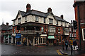
10
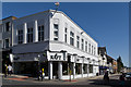
2 Chequer Street
An art deco building on the corner of Chequer Street and London Road, housing a furniture store, originally built in the c.1930s for the menswear company, Burtons.
Image: © Ian Capper
Taken: 20 Apr 2013
0.02 miles