IMAGES TAKEN NEAR TO
Pearces Walk, ST. ALBANS, AL1 1NN
Introduction
This page details the photographs taken nearby to Pearces Walk, AL1 1NN by members of the Geograph project.
The Geograph project started in 2005 with the aim of publishing, organising and preserving representative images for every square kilometre of Great Britain, Ireland and the Isle of Man.

There are currently over 7.5m images from over14,400 individuals and you can help contribute to the project by visiting https://www.geograph.org.uk
Image Map
Images are licensed for reuse under creativecommons.org/licenses/by-sa/2.0
Notes
- Clicking on the map will re-center to the selected point.
- The higher the marker number, the further away the image location is from the centre of the postcode.
Image Listing (692 Images Found)
Images are licensed for reuse under creativecommons.org/licenses/by-sa/2.0
Image
Details
Distance
1
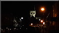
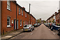
Pageant Road, St Albans and the floodlit cathedral bell tower
This Victorian or Edwardian terraced residential street frames the cathedral and is on the same axis.
Image: © Chris Brown
Taken: 25 Oct 2017
0.01 miles
2
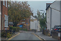
St Albans : Albert Street
Looking along a narrow lane.
Image: © Lewis Clarke
Taken: 4 Oct 2018
0.02 miles
3
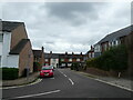
Looking from Hart Road into Pageant Road
Image: © Basher Eyre
Taken: 29 Aug 2021
0.03 miles
4
Looking east-southeast along Pageant Road
Image: © Basher Eyre
Taken: 29 Aug 2021
0.03 miles
5
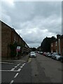
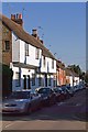
Pageant Road
Developed in the Edwardian era on burgage plots to the rear of Holywell Hill. the road was named after a great pageant that took place in St Albans in 1907. All the buildings here are locally listed. In the background is St Albans Abbey.
On the wall of the first building on the left can be seen a World War 1 Street Memorial (see Image for close up).
Image: © Ian Capper
Taken: 3 May 2012
0.04 miles
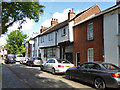
6
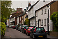
Sopwell Lane
The old route into St Albans from London, as a continuation of Old London Road, until the building of the current London Road by Thomas Telford in the late 18th century. All the buildings on the north (right hand side here) side of the road are either grade II listed or locally listed, reflecting its historic importance and its preservation as a medieval route.
In particular, no 53/55 (the white building with the projecting first floor) is grade II listed, dating from the 16th century - see www.historicengland.org.uk/listing/the-list/list-entry/1103060.
In the background is the tower of St Albans Abbey.
Image: © Ian Capper
Taken: 3 May 2012
0.04 miles
8
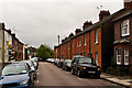
Pageant Road
Developed in the Edwardian era on burgage plots to the rear of Holywell Hill. the road was named after a great pageant that took place in St Albans in 1907. All the buildings here are locally listed.
Image: © Ian Capper
Taken: 3 May 2012
0.04 miles
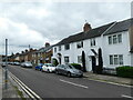
9
The Goat Inn, St Albans
On Sopwell Lane, it is a 16th century grade II listed building.
Image: © Robin Webster
Taken: 14 May 2017
0.05 miles
10
Sopwell Lane
The old route into St Albans from London, as a continuation of Old London Road, until the building of the current London Road by Thomas Telford in the late 18th century. All the buildings on the north side of the road are either grade II listed or locally listed, reflecting its historic importance and its preservation as a medieval route. In particular the nearest range of buildings in this photo, nos 63 - 69, dates from the 16th century and is grade II listed - see www.historicengland.org.uk/listing/the-list/list-entry/1174493 while the house beyond, no 71, dates from the 18th century and is also grade II listed - see www.historicengland.org.uk/listing/the-list/list-entry/1347168.
Image: © Ian Capper
Taken: 2 Oct 2011
0.05 miles