IMAGES TAKEN NEAR TO
Westbourne Mews, ST. ALBANS, AL1 1LS
Introduction
This page details the photographs taken nearby to Westbourne Mews, AL1 1LS by members of the Geograph project.
The Geograph project started in 2005 with the aim of publishing, organising and preserving representative images for every square kilometre of Great Britain, Ireland and the Isle of Man.

There are currently over 7.5m images from over14,400 individuals and you can help contribute to the project by visiting https://www.geograph.org.uk
Image Map
Images are licensed for reuse under creativecommons.org/licenses/by-sa/2.0
Notes
- Clicking on the map will re-center to the selected point.
- The higher the marker number, the further away the image location is from the centre of the postcode.
Image Listing (844 Images Found)
Images are licensed for reuse under creativecommons.org/licenses/by-sa/2.0
Image
Details
Distance
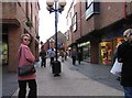
4
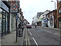
London Road (A1081), St Albans
Looking north west.
Image: © JThomas
Taken: 18 Mar 2017
0.03 miles
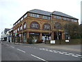
7
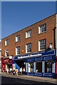
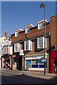
8 - 10 Chequer Street
Although clearly a twentieth century frontage, an 1880 street plan shows the site as having been occupied by the Queen's Hotel on the left half of the site and a straw hat factory on the right half, divided by the carriage way which still remains to give access to the rear of the site. The building is locally listed.
Image: © Ian Capper
Taken: 2 Oct 2011
0.04 miles
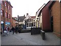
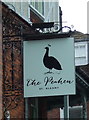
8
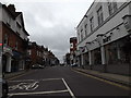
12 - 14 Chequer Street
No 12, on the right is a modern building, while No 14, the former Bat and Ball pub is much older, dating originally from the 16th century. It is grade II listed - for listing particulars see www.historicengland.org.uk/listing/the-list/list-entry/1347180.
Image: © Ian Capper
Taken: 2 Oct 2011
0.04 miles
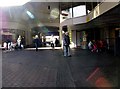
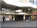
9
A1081 London Road, St.Albans
At the junction with the A5183 High Street, A5183 Holywell Hill & A1081 Chequer Street
Image: © Geographer
Taken: 9 Nov 2015
0.04 miles