IMAGES TAKEN NEAR TO
Cottonmill Lane, ST. ALBANS, AL1 1HJ
Introduction
This page details the photographs taken nearby to Cottonmill Lane, AL1 1HJ by members of the Geograph project.
The Geograph project started in 2005 with the aim of publishing, organising and preserving representative images for every square kilometre of Great Britain, Ireland and the Isle of Man.

There are currently over 7.5m images from over14,400 individuals and you can help contribute to the project by visiting https://www.geograph.org.uk
Image Map
Images are licensed for reuse under creativecommons.org/licenses/by-sa/2.0
Notes
- Clicking on the map will re-center to the selected point.
- The higher the marker number, the further away the image location is from the centre of the postcode.
Image Listing (132 Images Found)
Images are licensed for reuse under creativecommons.org/licenses/by-sa/2.0
Image
Details
Distance
1
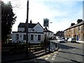
St Albans : Cottonmill Lane
Looking along Cottonmill Lane.
Image: © Lewis Clarke
Taken: 4 Oct 2018
0.00 miles
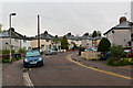
2
Cottonmill Lane
c.1930s housing in Cottonmill Lane, on the section running up to Old London Road. The block in the background, on Old London Road itself, is much older, being early 19th Century.
Image: © Ian Capper
Taken: 5 Aug 2021
0.05 miles
3
Cottonmill Lane
c.1930s housing in Cottonmill Crescent, off Cottonmill Lane.
Image: © Ian Capper
Taken: 5 Aug 2021
0.05 miles
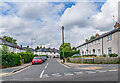
4
Cottonmill Crescent
1930s pebble-dashed housing in a road connecting Cottonmill Lane and Old London Road.
Image: © Ian Capper
Taken: 3 May 2012
0.07 miles
5
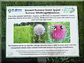
Sopwell Nunnery Information Board (2)
Located on the Abbey Line Trail in Sopwell Nunnery https://www.walkingenglishman.com/ldp/abbeylinetrail.html refers, this board has been erected by St Albans District Council and has the following wording:
Sopwell Nunnery Green Space:
Summer Wildflower Meadows.
This is the summer wildflower meadow and provides an important habitat for
wildlife, especially insects which feed on nectar. Wildflowers thrive in areas
with nutrient poor soils and high light levels.
The images in the middle show the following from left to right:
Natural Grassland, Field Scabious and Bumblebees.
The meadow will be cut and the cuttings removed twice a year. In a few years
time this management should lower nutrient levels and promote the growth of
wildflowers.
Image: © David Hillas
Taken: 30 May 2019
0.07 miles
6
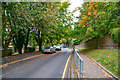
St Albans : Riverside Road
Looking along Riverside Road.
Image: © Lewis Clarke
Taken: 4 Oct 2018
0.09 miles
7
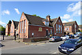
Former school, Old London Road, St Albans
Now flats, the stone in the wall tells us that this was founded in 1900 as the St Albans School Board's Priory Park Boys School.
Image: © Robin Webster
Taken: 14 May 2017
0.09 miles
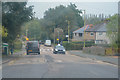
8
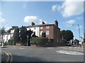
Old London Road at the junction of Cottonmill Lane
Image: © David Howard
Taken: 22 Jul 2014
0.09 miles
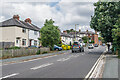
9
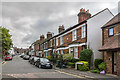
Thorpe Road
Road of late 19th Century terraced houses, first shown on the 1898 1:2,500 map.
Image: © Ian Capper
Taken: 24 Jul 2020
0.10 miles