IMAGES TAKEN NEAR TO
Belmont Hill, ST. ALBANS, AL1 1BH
Introduction
This page details the photographs taken nearby to Belmont Hill, AL1 1BH by members of the Geograph project.
The Geograph project started in 2005 with the aim of publishing, organising and preserving representative images for every square kilometre of Great Britain, Ireland and the Isle of Man.

There are currently over 7.5m images from over14,400 individuals and you can help contribute to the project by visiting https://www.geograph.org.uk
Image Map
Images are licensed for reuse under creativecommons.org/licenses/by-sa/2.0
Notes
- Clicking on the map will re-center to the selected point.
- The higher the marker number, the further away the image location is from the centre of the postcode.
Image Listing (190 Images Found)
Images are licensed for reuse under creativecommons.org/licenses/by-sa/2.0
Image
Details
Distance
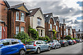
1
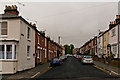
Thorpe Road
Road of late 19th Century terraced houses, first shown on the 1898 1:2,500 map.
Image: © Ian Capper
Taken: 24 Jul 2020
0.02 miles
2
Cottonmill Lane
c.1930s housing in Cottonmill Crescent, off Cottonmill Lane.
Image: © Ian Capper
Taken: 5 Aug 2021
0.05 miles
3
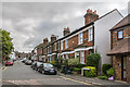
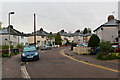
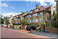
Belmont Hill
Late Victorian houses in Belmont Hill.
Image: © Ian Capper
Taken: 24 Jul 2020
0.05 miles
4
Belmont Hill
Late Victorian houses in Belmont Hill.
Image: © Ian Capper
Taken: 24 Jul 2020
0.05 miles
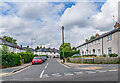
5
Cottonmill Crescent
1930s pebble-dashed housing in a road connecting Cottonmill Lane and Old London Road.
Image: © Ian Capper
Taken: 3 May 2012
0.05 miles
6
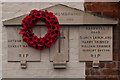
World War 1 Street Memorial, Bardwell Road
See description below. This one is in Bardwell Road, commemorating the dead of this road and neighbouring Thorpe Road. It as dedicated in June 1920.
For context see Image
Image: © Ian Capper
Taken: 3 May 2012
0.05 miles
7
Belmont Hill
Late Victorian houses in Belmont Hill.
Image: © Ian Capper
Taken: 24 Jul 2020
0.06 miles
8
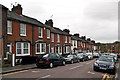
Thorpe Road
Victorian housing, all locally listed.
Image: © Ian Capper
Taken: 3 May 2012
0.06 miles
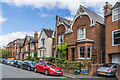
9
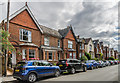
Bardwell Road
Late Victorian terrace housing. The building on the left, at its junction with Thorpe Road, is a former shop. All are locally listed.
In the wall on the left can be seen a World War 1 Street Memorial (see Image for close up).
Image: © Ian Capper
Taken: 3 May 2012
0.06 miles
10
Belmont Hill
Early 20th Century houses in Belmont Hill.
Image: © Ian Capper
Taken: 24 Jul 2020
0.08 miles