IMAGES TAKEN NEAR TO
Orient Close, ST. ALBANS, AL1 1AJ
Introduction
This page details the photographs taken nearby to Orient Close, AL1 1AJ by members of the Geograph project.
The Geograph project started in 2005 with the aim of publishing, organising and preserving representative images for every square kilometre of Great Britain, Ireland and the Isle of Man.

There are currently over 7.5m images from over14,400 individuals and you can help contribute to the project by visiting https://www.geograph.org.uk
Image Map
Images are licensed for reuse under creativecommons.org/licenses/by-sa/2.0
Notes
- Clicking on the map will re-center to the selected point.
- The higher the marker number, the further away the image location is from the centre of the postcode.
Image Listing (76 Images Found)
Images are licensed for reuse under creativecommons.org/licenses/by-sa/2.0
Image
Details
Distance
1
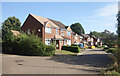
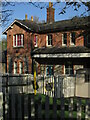
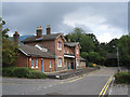
Orient Close, St Albans
Housing beside the Alban Way, a cycle path along an old railway line between Hatfield and St Albans.
Image: © Des Blenkinsopp
Taken: 25 Aug 2024
0.03 miles
2
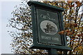
Old Station sign
This sign is at the old St Albans London Road station. The station itself is perfectly preserved and now appears to be more of a children's early learning centre than a business centre. The sign itself has a fine example of a locomotive picture.
Image: © Robert Eva
Taken: 3 Nov 2016
0.04 miles
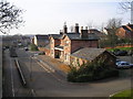
4
Old Station on the Alban Way
The Alban Way is a footpath and cycleway along a former railway line between Hatfield and St Albans. Although quite a short line it had stations at frequent intervals.
This is London Road Station, the largest and best preserved one on the line. It's now a children's nursery. A couple of the other stations have been smartened up by local enthusiasts but the rest are now overgrown and neglected.
Image: © Des Blenkinsopp
Taken: 25 Aug 2024
0.05 miles
5
St Albans former London Road station
Now the Monkey Puzzle Day Nursery at Orient Close, St Albans, formerly the principal station on the GNR Great Northern Railway branch from Hatfield. However, the branch went on further to connect to the LNWR Watford Junction to St Albans branch railway at its St Albans Abbey terminus station.
Hertfordshire, UK.
Opened in 1865 (Wikipedia)
Image: © Simon Marshall
Taken: 16 Apr 2022
0.05 miles
6
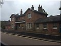
The Old Station in St Albans
This is the old station from the St Albans to Hatfield Railway. It is now offices and a cycle and footpath replace the tracks. Photographed from the road bridge on London Road.It was called 'St Albans' Station, later renamed 'St Albans London Road' in 1950.
It was first opened 16th October 1865, closed to passengers 1st October 1951 and finally the freight traffic ceased on 5th October 1964.
Image: © Barry Lawson
Taken: 24 Jan 2006
0.06 miles
7
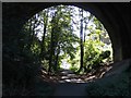
Railway Bridge over the Alban Way
Just near London Road is a pedestrian route from St.Albans to Hatfield.
Image: © Martin Stewart
Taken: 5 Sep 2004
0.06 miles
8
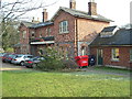
The Old St Albans Station
This is the old station from the St Albans to Hatfield Railway. It is now offices and a cycle and footpath replace the tracks. Photographed from Orient Close. It was called 'St Albans' Station, later renamed 'St Albans London Road' in 1950.
It was first opened 16th October 1865, closed to passengers 1st October 1951 and finally the freight traffic ceased on 5th October 1964.
Image: © Barry Lawson
Taken: 24 Jan 2006
0.06 miles
9
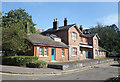
London Road railway station (disused)
The station has been subsumed in a small housing estate. The railway ran where the road now is and went under the bridge carrying the A1081 (old A6) over it, to the right of the picture. Now renovated, the old station building houses a children's day nursery.
The route of the old railway from St. Albans Abbey station to Hatfield is now the Alban Way, a path for walkers and cyclists and is a section of National Cycle Network Route 61.
Image: © Jeremy Withrington
Taken: 14 Sep 2014
0.06 miles
10
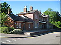
St Albans: Former London Road railway station
In the past St Albans had several railway stations. For most of its life this one was *the* St Albans station, only obtaining the London Road suffix in 1950, a year before its closure to passenger traffic. It was on the Hatfield and St Albans Railway and opened in 1865. It is now a business centre, named after the residential road and estate that was built over the railway and the former station sidings, Orient Close.
Image: © Nigel Cox
Taken: 29 May 2009
0.06 miles