IMAGES TAKEN NEAR TO
Grange, KEITH, AB55 6RY
Introduction
This page details the photographs taken nearby to AB55 6RY by members of the Geograph project.
The Geograph project started in 2005 with the aim of publishing, organising and preserving representative images for every square kilometre of Great Britain, Ireland and the Isle of Man.

There are currently over 7.5m images from over14,400 individuals and you can help contribute to the project by visiting https://www.geograph.org.uk
Image Map
Images are licensed for reuse under creativecommons.org/licenses/by-sa/2.0
Notes
- Clicking on the map will re-center to the selected point.
- The higher the marker number, the further away the image location is from the centre of the postcode.
Image Listing (9 Images Found)
Images are licensed for reuse under creativecommons.org/licenses/by-sa/2.0
Image
Details
Distance
1
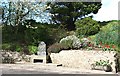
Grange War Memorial
It was the cheerful floral surroundings which caught my eye as I was passing. Unfortunately this memorial is very awkwardly sited in relation to traffic, which passes at high speed, so it is easy to overlook it.
Image: © Anne Burgess
Taken: 26 Apr 2007
0.09 miles
2
Clerkseat Bridge and Little Clerkseat
The bridge carries the A95 over the Burn of Paithnick, and Little Clerkseat is the farm among the trees on the right. The new houses at top left of this view are not marked on the maps yet.
Image: © Anne Burgess
Taken: 13 Feb 2009
0.13 miles
3
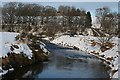
River Isla and Bridge of Grange
The Bridge of Grange, on the right in this view, carries the access road to Cantly over a meander of the River Isla.
Image: © Anne Burgess
Taken: 13 Feb 2009
0.15 miles
4
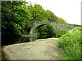
Bridge at Davoch of Grange near Keith
The bridge carries a minor road south from A95 over the River Isla.
Image: © Christopher Gillan
Taken: 29 May 2006
0.17 miles
5
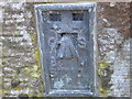
Ordnance Survey Flush Bracket S7110
This can be found on the wall of St Ninians Church.
For more detail see : http://www.bench-marks.org.uk/bm20966
Image: © Peter Wood
Taken: 4 Oct 2012
0.17 miles
6
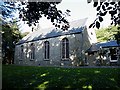
St Ninian's Kirk
The dedication of this kirk to St Ninian is almost forgotten now. The kirk is still used fortnightly, and now belongs to the united parishes of Keith, Botriphnie and Grange. This is ironic, in a way, because the parish of Grange was originally created by splitting it off from the parish of Keith in 1618. Sic transit gloria mundi.
Image: © Anne Burgess
Taken: 8 Oct 2008
0.17 miles
7
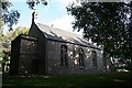
Grange Parish Kirk
The present kirk was built in 1795 on the site of the chapel of St Mary's Monastery, a Cistercian foundation, dedicated in 1525. It stands on a partly artificial mound, and the surrounding trees make it very difficult to photograph well.
Image: © Anne Burgess
Taken: 8 Oct 2008
0.18 miles
8
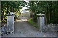
Entrance to Grange Kirk
The back of the kirk, visible from the gate, is a blank wall, making the building look a bit like a barn from here.
Image: © Anne Burgess
Taken: 8 Oct 2008
0.19 miles
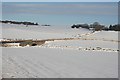
9
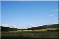
The Strath
Farmland and woodland in Strathisla with Little Balloch Hill in the distance on the right.
Image: © Andrew Wood
Taken: 17 Aug 2011
0.24 miles