IMAGES TAKEN NEAR TO
KEITH, AB55 6RR
Introduction
This page details the photographs taken nearby to AB55 6RR by members of the Geograph project.
The Geograph project started in 2005 with the aim of publishing, organising and preserving representative images for every square kilometre of Great Britain, Ireland and the Isle of Man.

There are currently over 7.5m images from over14,400 individuals and you can help contribute to the project by visiting https://www.geograph.org.uk
Image Map
Images are licensed for reuse under creativecommons.org/licenses/by-sa/2.0
Notes
- Clicking on the map will re-center to the selected point.
- The higher the marker number, the further away the image location is from the centre of the postcode.
Image Listing (6 Images Found)
Images are licensed for reuse under creativecommons.org/licenses/by-sa/2.0
Image
Details
Distance
1
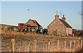
Cottage at Muldearie
The cottage stands at the foot of the road to Hillockhead of Muldearie.
Image: © Anne Burgess
Taken: 5 Jan 2009
0.01 miles

3
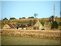
Hillockhead of Muldearie
From this rather distant spot, it looks as if Hillockhead is one of the many farms which are abandoned and becoming derelict.
Image: © Anne Burgess
Taken: 5 Jan 2009
0.23 miles
4
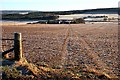
Mains of Muldearie
It's handy to be able to take a short cut across the fields to wherever you need to be!
Image: © Anne Burgess
Taken: 5 Jan 2009
0.24 miles
5
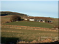
Muldearie Mains, near Keith
Muldearie Mains Farm on a frosty January morning.
Image: © Christopher Gillan
Taken: 4 Jan 2006
0.24 miles
6
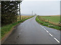
Minor road at Strypeside of Muldearie
Looking south-westward
Image: © Peter Wood
Taken: 25 Oct 2018
0.24 miles