IMAGES TAKEN NEAR TO
Crossroads, KEITH, AB55 6NE
Introduction
This page details the photographs taken nearby to AB55 6NE by members of the Geograph project.
The Geograph project started in 2005 with the aim of publishing, organising and preserving representative images for every square kilometre of Great Britain, Ireland and the Isle of Man.

There are currently over 7.5m images from over14,400 individuals and you can help contribute to the project by visiting https://www.geograph.org.uk
Image Map
Images are licensed for reuse under creativecommons.org/licenses/by-sa/2.0
Notes
- Clicking on the map will re-center to the selected point.
- The higher the marker number, the further away the image location is from the centre of the postcode.
Image Listing (6 Images Found)
Images are licensed for reuse under creativecommons.org/licenses/by-sa/2.0
Image
Details
Distance
1
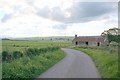
Upper Burnend
The ditch is part of a complex of ditches that eventually become part of the Bowie Burn. The new house at Upper Burnend isn't yet on the maps.
Image: © Anne Burgess
Taken: 20 Apr 2022
0.03 miles
2
Abandoned at Burnend
Old abandoned cottage
Image: © Ralph Greig
Taken: 12 Feb 2023
0.18 miles
3
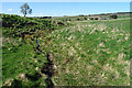
Mill Lade
This is shown on the 19th century maps as a mill lade, presumably powering a mill at Burnend, though no mill is actually named. The farm buildings are at Goukstone.
Image: © Anne Burgess
Taken: 20 Apr 2022
0.19 miles
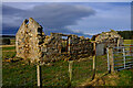
4
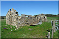
Ruin at Burnend
Evidently the remains of a house, this is marked on the 19th century maps but not named. It has deteriorated significantly in the 16 years since Image] was taken.
Image: © Anne Burgess
Taken: 20 Apr 2022
0.19 miles
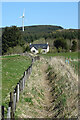
5

Field Access
The track flanked by fences on both sides just leads into a field which is behind me. The farm buildings are at Goukstone, and Black Hill is on the skyline.
Image: © Anne Burgess
Taken: 20 Apr 2022
0.21 miles