IMAGES TAKEN NEAR TO
KEITH, AB55 5PN
Introduction
This page details the photographs taken nearby to AB55 5PN by members of the Geograph project.
The Geograph project started in 2005 with the aim of publishing, organising and preserving representative images for every square kilometre of Great Britain, Ireland and the Isle of Man.

There are currently over 7.5m images from over14,400 individuals and you can help contribute to the project by visiting https://www.geograph.org.uk
Image Map
Images are licensed for reuse under creativecommons.org/licenses/by-sa/2.0
Notes
- Clicking on the map will re-center to the selected point.
- The higher the marker number, the further away the image location is from the centre of the postcode.
Image Listing (5 Images Found)
Images are licensed for reuse under creativecommons.org/licenses/by-sa/2.0
Image
Details
Distance
1
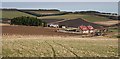
Bomakelloch Cottages
The pair of more modern cottages are in square, while the old farm beyond is just in the next square.
Image: © Anne Burgess
Taken: 30 Jan 2008
0.00 miles
2
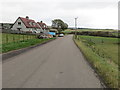
Bomakelloch Cottages beside the B9115 road
Looking north-eastward
Image: © Peter Wood
Taken: 23 Oct 2018
0.02 miles

4
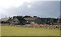
Bomakelloch
The traditional farm house is set back from the road beside which the modern bungalows have been built. The dark clouds announced a prolonged blustery squall approaching from the west.
Image: © Anne Burgess
Taken: 25 Feb 2009
0.17 miles
5
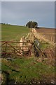
March and Burn
The burn almost certainly marks the march between Mains of Drummuir to the left and Bomakelloch to the right. The stand of trees is in an adjacent square.
Image: © Anne Burgess
Taken: 30 Jan 2008
0.17 miles