IMAGES TAKEN NEAR TO
KEITH, AB55 5NT
Introduction
This page details the photographs taken nearby to AB55 5NT by members of the Geograph project.
The Geograph project started in 2005 with the aim of publishing, organising and preserving representative images for every square kilometre of Great Britain, Ireland and the Isle of Man.

There are currently over 7.5m images from over14,400 individuals and you can help contribute to the project by visiting https://www.geograph.org.uk
Image Map
Images are licensed for reuse under creativecommons.org/licenses/by-sa/2.0
Notes
- Clicking on the map will re-center to the selected point.
- The higher the marker number, the further away the image location is from the centre of the postcode.
Image Listing (13 Images Found)
Images are licensed for reuse under creativecommons.org/licenses/by-sa/2.0
Image
Details
Distance
1
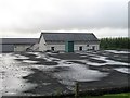
Herricks Waterworks
Waterworks serving Keith. Draws water from burns on Balloch Hill.
Image: © Richard Webb
Taken: 6 Aug 2007
0.02 miles
2
Herricks Water Treatment Works
The plant, on the slope of Meikle Balloch, provides water for the town of Keith. Just above it is the car park for walkers using the forest walks on the hill.
Image: © Anne Burgess
Taken: 30 Oct 2020
0.02 miles
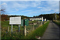
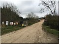
3
Entrance to Balloch Car Park
A good size car park for the Balloch
Image: © Ralph Greig
Taken: 13 Mar 2022
0.04 miles
4
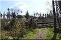
No Way!
The path up from the car park is comprehensively obstructed by trees blown down during Storm Arwen. Fortunately this is just a popular short cut, and the slightly longer way round by road is clear of fallen trees. No doubt Forest and Land Scotland will eventually get round to clearing it, once the higher priority work has been done.
Image: © Anne Burgess
Taken: 28 Apr 2022
0.05 miles
6
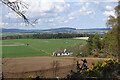
Dwarick House
The house stands in an elevated position with a broad view across Strath Isla and Keith, which is towards the right.
Image: © Anne Burgess
Taken: 28 Apr 2022
0.10 miles
7
Auchoynanie from Herricks
Mains of Auchoynanie is the large farm in the middle distance.
Image: © Anne Burgess
Taken: 13 Feb 2008
0.10 miles
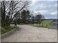
8
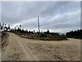
View of a junction
A simple junction taking you to either the car or the hill
Image: © Ralph Greig
Taken: 13 Mar 2022
0.15 miles
9
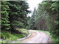
Balloch Wood
Forest road in Balloch Wood.
Image: © Richard Webb
Taken: 6 Aug 2007
0.16 miles
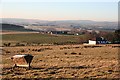
10
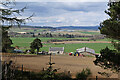
Wester Herricks
A farm with a view, on the slope of The Balloch. These day the view takes in the pale scar of Blackhillock Quarry, on the left; the vast Blackhillock electricity transformer in the middle distance, with its attendant power lines; and the wind turbines in the Drummuir wind farm on the skyline.
Image: © Anne Burgess
Taken: 28 Apr 2022
0.17 miles