IMAGES TAKEN NEAR TO
Balloch Road, KEITH, AB55 5EN
Introduction
This page details the photographs taken nearby to Balloch Road, AB55 5EN by members of the Geograph project.
The Geograph project started in 2005 with the aim of publishing, organising and preserving representative images for every square kilometre of Great Britain, Ireland and the Isle of Man.

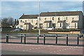
There are currently over 7.5m images from over14,400 individuals and you can help contribute to the project by visiting https://www.geograph.org.uk
Image Map
Images are licensed for reuse under creativecommons.org/licenses/by-sa/2.0
Notes
- Clicking on the map will re-center to the selected point.
- The higher the marker number, the further away the image location is from the centre of the postcode.
Image Listing (103 Images Found)
Images are licensed for reuse under creativecommons.org/licenses/by-sa/2.0
Image
Details
Distance
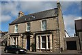
2
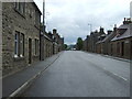
Moss Street
Moss Street is the main A96 trunk road through Keith. Its efficacy as a bottleneck is greatly enhanced by the installation of traffic lights at the entrance to a large supermarket which was permitted to obliterate part of the traditional street in favour of a vast car park.
Image: © Anne Burgess
Taken: 23 Feb 2021
0.07 miles
3
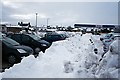
Snowbound Car Park
Tesco has done a fine job of clearing the parking spaces of snow. Wasn't it lucky there is a footpath available to dump the stuff on?
Image: © Anne Burgess
Taken: 11 Jan 2010
0.07 miles
4
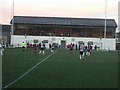
Kynoch Park
Home of Keith FC. This game in December 2006 finished Keith 2 Fraserburgh 2.
Keith FC (maroon shirts) went on the become Highland League Champions for 2006/07 season
Image: © Ken Fitlike
Taken: 1 Dec 2006
0.07 miles
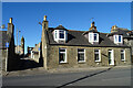
5
124 Moss Street
A stone villa with rather more elaborate detailing than most of the houses on Moss Street.
Image: © Anne Burgess
Taken: 26 Feb 2021
0.07 miles
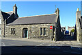
6
Moss Street and Institute Lane
About 20 narrow lanes link the main streets of Keith. Institute Lane is named after the Institute, the building with the prominent clock tower in Mid Street.
Image: © Anne Burgess
Taken: 26 Feb 2021
0.08 miles
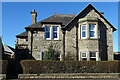
7
Weston House
This house was built in 1885 by Peter Laing, whose family home it was. It is now a care home for elderly people.
Image: © Anne Burgess
Taken: 19 Aug 2007
0.08 miles
8
Bankers Lane
One of the numerous lanes that link the mains streets of Keith, viewed from Moss Street. It's quite common to find a lane blocked by a vehicle delivering or collecting goods, but there is always another lane not far away.
Image: © Anne Burgess
Taken: 26 Feb 2021
0.08 miles
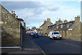
9
Westerton Road
Actually, this shows the rear of houses in Westerton Road, which now enjoy easy access to Tesco, and an open view across its car park.
Image: © Anne Burgess
Taken: 6 Mar 2009
0.09 miles
10
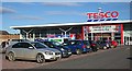
Tesco Supermarket
One of the recent moves in Tesco's campaign for world domination, this new store opened in 2008. Construction entailed breaching the row of traditional stone houses on Moss Street and replacing them with a set of traffic lights, which in my view did not improve the appearance of the street. It could have been worse - the road planners might have indulged their passion for roundabouts.
Image: © Anne Burgess
Taken: 6 Mar 2009
0.09 miles