IMAGES TAKEN NEAR TO
Dufftown Industrial Estate, KEITH, AB55 4FR
Introduction
This page details the photographs taken nearby to Dufftown Industrial Estate, AB55 4FR by members of the Geograph project.
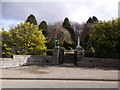
The Geograph project started in 2005 with the aim of publishing, organising and preserving representative images for every square kilometre of Great Britain, Ireland and the Isle of Man.

There are currently over 7.5m images from over14,400 individuals and you can help contribute to the project by visiting https://www.geograph.org.uk
Image Map
Images are licensed for reuse under creativecommons.org/licenses/by-sa/2.0
Notes
- Clicking on the map will re-center to the selected point.
- The higher the marker number, the further away the image location is from the centre of the postcode.
Image Listing (31 Images Found)
Images are licensed for reuse under creativecommons.org/licenses/by-sa/2.0
Image
Details
Distance
1
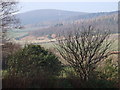
View from War Memorial garden, Dufftown.
Ben Rinnes [NJ2535; 841m] features in the distance.
Image: © Stanley Howe
Taken: 26 Mar 2007
0.07 miles
2
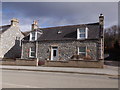
A cottage on Balvenie St, Dufftown
A941 to Glenfiddich Distillery and north.
Image: © Stanley Howe
Taken: 5 Mar 2015
0.07 miles
3
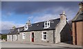
Inveravon, Balvenie St, Dufftown
By A941 heading north.
Image: © Stanley Howe
Taken: 5 Mar 2015
0.08 miles
4
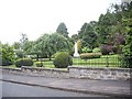
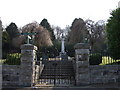
War Memorial Garden, Dufftown
Seen from Balvenie Road (A941).
Image: © Stanley Howe
Taken: 7 Aug 2013
0.09 miles
5

Lest We Forget Dufftown
The war memorial fir Dufftown
Image: © Ralph Greig
Taken: 23 Jan 2022
0.09 miles
6
War Memorial Gardens
Off Balvenie Street (A941), Dufftown.
Image: © Stanley Howe
Taken: 5 Mar 2015
0.09 miles
7
Glenfiddich Distillery
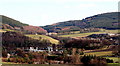
Glenfiddich Distillery in foreground with Parkmore Quarry on right with road up through valley to Drumuir, taken from Dufftown to Aberlour footpath distance of approx 3kl. away
Image: © John Brailsford
Taken: 8 Mar 2007
0.10 miles
8
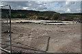
A Brownfield Site
The maps still show buildings here, and the older maps name them as Auction Mart and Slaughterhouse. I expect it will not be long before houses pop up.
Image: © Anne Burgess
Taken: 10 Apr 2014
0.10 miles
9
War Memorial garden, Dufftown
The signpost indicates the 'Isla Way' footpath passes here.
Image: © Stanley Howe
Taken: 26 Mar 2007
0.10 miles
10
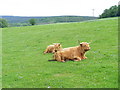
Highland Cattle
This field extends from Balvenie castle to the A941, a road which runs
from Lossiemouth to Rhynie in its extremities. Highland cattle can often be seen at this location.
Image: © Ann Harrison
Taken: 1 Jun 2010
0.11 miles