IMAGES TAKEN NEAR TO
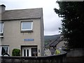
Ferrier Road, KEITH, AB55 4ES
Introduction
This page details the photographs taken nearby to Ferrier Road, AB55 4ES by members of the Geograph project.
The Geograph project started in 2005 with the aim of publishing, organising and preserving representative images for every square kilometre of Great Britain, Ireland and the Isle of Man.

There are currently over 7.5m images from over14,400 individuals and you can help contribute to the project by visiting https://www.geograph.org.uk
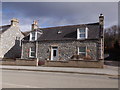
Image Map
Images are licensed for reuse under creativecommons.org/licenses/by-sa/2.0
Notes
- Clicking on the map will re-center to the selected point.
- The higher the marker number, the further away the image location is from the centre of the postcode.
Image Listing (52 Images Found)
Images are licensed for reuse under creativecommons.org/licenses/by-sa/2.0
Image
Details
Distance
1
Top end of Louise Street, Dufftown
A cul-de-sac.
Image: © Stanley Howe
Taken: 7 Aug 2013
0.03 miles
2
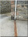
OS Cut Mark, Dufftown, 64 Balvenie Street
OS Cut Mark, Dufftown, 64 Balvenie Street - very clear mark
Image: © thejackrustles
Taken: 13 May 2015
0.04 miles
3
Dalry, 57 Balvenie St, Dufftown
On A941 opposite Hill Street.
Image: © Stanley Howe
Taken: 5 Mar 2015
0.05 miles
4
Inveravon, Balvenie St, Dufftown
By A941 heading north.
Image: © Stanley Howe
Taken: 5 Mar 2015
0.07 miles
5
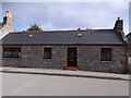
A cottage on Balvenie St, Dufftown
A941 to Glenfiddich Distillery and north.
Image: © Stanley Howe
Taken: 5 Mar 2015
0.08 miles
6
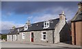
Semi-detached cottage on Balvenie St, Dufftown
By A941, between Hill Street and Albert Place.
Image: © Stanley Howe
Taken: 5 Mar 2015
0.09 miles
7
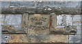
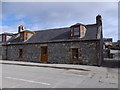
Panel above the Door
Just for the avoidance of any doubt, this is the panel above the Hill Street door to Image
Image: © Anne Burgess
Taken: 10 Apr 2014
0.12 miles
8
Police Station
The former police station is rather out of the way, tucked away on the corner of York Street and Hill Street. It was built in 1897, and the architect was Francis D Robertson (1839-1922) from Keith. (He was baptised Francis Davidson Robertson but in later life he called himself Francis Duff Robertson.) I believe it is now private housing.
Image: © Anne Burgess
Taken: 10 Apr 2014
0.12 miles
9
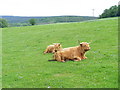
Highland Cattle
This field extends from Balvenie castle to the A941, a road which runs
from Lossiemouth to Rhynie in its extremities. Highland cattle can often be seen at this location.
Image: © Ann Harrison
Taken: 1 Jun 2010
0.12 miles
10
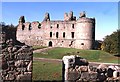
Balvenie Castle
Balvenie Castle is a 13th century courtyard castle, to which a Renaissance façade was later added. Mary Queen of Scots stayed here in 1562
Image: © Anne Burgess
Taken: Unknown
0.12 miles