IMAGES TAKEN NEAR TO
Dufftown, KEITH, AB55 4BN
Introduction
This page details the photographs taken nearby to AB55 4BN by members of the Geograph project.
The Geograph project started in 2005 with the aim of publishing, organising and preserving representative images for every square kilometre of Great Britain, Ireland and the Isle of Man.

There are currently over 7.5m images from over14,400 individuals and you can help contribute to the project by visiting https://www.geograph.org.uk
Image Map
Images are licensed for reuse under creativecommons.org/licenses/by-sa/2.0
Notes
- Clicking on the map will re-center to the selected point.
- The higher the marker number, the further away the image location is from the centre of the postcode.
Image Listing (9 Images Found)
Images are licensed for reuse under creativecommons.org/licenses/by-sa/2.0
Image
Details
Distance
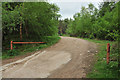
2
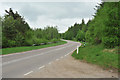
A941 between Craigellachie and Dufftown
Image: © Steven Brown
Taken: 23 May 2010
0.10 miles
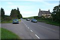
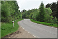
3
Spring Croft
The two cottages at Spring Croft look quite remote from this viewpoint, but in fact they stand right beside the A941. Part of the Buchromb woods is on the hill beyond, and Ben Aigen dominates the skyline.
Image: © Anne Burgess
Taken: 22 Oct 2012
0.11 miles
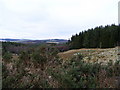
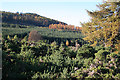
7
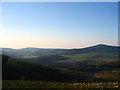
A Disappearing View
This view will not be seen in a couple of years due to the young plantation in the foreground.
Image: © James Combe
Taken: 7 May 2008
0.17 miles
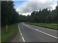
8
A941 between Craigellachie and Dufftown
Image: © Steven Brown
Taken: 23 May 2010
0.19 miles
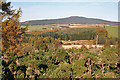
9
Blue Hill
Much of Blue Hill is forested. This is the northern end of the hill, the summit being further to the left.
Image: © Anne Burgess
Taken: 22 Oct 2012
0.24 miles