IMAGES TAKEN NEAR TO
James Presly Court, HUNTLY, AB54 8FL
Introduction
This page details the photographs taken nearby to James Presly Court, AB54 8FL by members of the Geograph project.
The Geograph project started in 2005 with the aim of publishing, organising and preserving representative images for every square kilometre of Great Britain, Ireland and the Isle of Man.

There are currently over 7.5m images from over14,400 individuals and you can help contribute to the project by visiting https://www.geograph.org.uk
Image Map
Images are licensed for reuse under creativecommons.org/licenses/by-sa/2.0
Notes
- Clicking on the map will re-center to the selected point.
- The higher the marker number, the further away the image location is from the centre of the postcode.
Image Listing (26 Images Found)
Images are licensed for reuse under creativecommons.org/licenses/by-sa/2.0
Image
Details
Distance
3

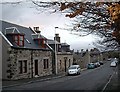
Bleachfield Street
One of the peripheral streets that enable traffic to avoid the narrow streets in the town centre of Huntly.
Image: © Anne Burgess
Taken: 19 Jul 2021
0.15 miles
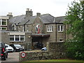
4
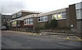
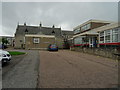
Huntly Hospital
Main Entrance; off Bleachfield Street.
Image: © Stanley Howe
Taken: 7 Dec 2009
0.16 miles
5
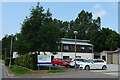
Deveron Dental Centre
A dentists' practice premises in Huntly.
Image: © Anne Burgess
Taken: 19 Jul 2021
0.18 miles
6
Huntly Cottage Hospital
Parts of the original building were used as an auxiliary hospital during the Great War.
Image: © John M
Taken: 4 Sep 2017
0.18 miles
7
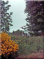
Huntly Signal Box
On the Aberdeen - Inverness railway line, which is single track for the vast majority of the journey, with trains passing at the stations like Huntly. The two signals and speed limit signs are for the two tracks which go through the station a few hundred metres along the line. One of the signals and one of the speed limit signs is for the "Loop" and one is for the "Mainline" which is only used at Huntly when there is a "Crossing" (Two trains passing) to save any problems with access to the platform for disabled and elderly.
Image: © Andrew Stuart
Taken: 28 May 2007
0.18 miles
8
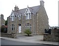
A town house in Huntly
Gladstone Road.
Image: © Stanley Howe
Taken: 13 Aug 2012
0.18 miles
9
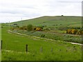
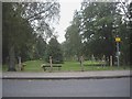
Railway line south of Huntly
Looking south west at Upper Pirriesmill with the south-eastern ridge of Clashmach Hill on the skyline.
Image: © Alan Murray-Rust
Taken: 20 May 2022
0.18 miles
10
Buildings at Huntly Cottage Hospital
The buildings were used as an auxiliary hospital during the Great War.
Image: © John M
Taken: 4 Sep 2017
0.19 miles