IMAGES TAKEN NEAR TO
Bydand Place, HUNTLY, AB54 8DN
Introduction
This page details the photographs taken nearby to Bydand Place, AB54 8DN by members of the Geograph project.
The Geograph project started in 2005 with the aim of publishing, organising and preserving representative images for every square kilometre of Great Britain, Ireland and the Isle of Man.

There are currently over 7.5m images from over14,400 individuals and you can help contribute to the project by visiting https://www.geograph.org.uk
Image Map
Images are licensed for reuse under creativecommons.org/licenses/by-sa/2.0
Notes
- Clicking on the map will re-center to the selected point.
- The higher the marker number, the further away the image location is from the centre of the postcode.
Image Listing (74 Images Found)
Images are licensed for reuse under creativecommons.org/licenses/by-sa/2.0
Image
Details
Distance
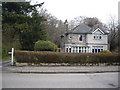
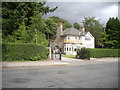
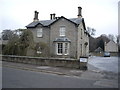
2
Westwood, Deveron Road
A villa in Huntly.
Image: © Stanley Howe
Taken: 27 Aug 2013
0.03 miles
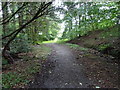
3
Bydand Place, Huntly
A cul-de-sac off Deveron Road.
Image: © Stanley Howe
Taken: 24 Apr 2010
0.04 miles
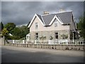
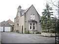
5
House with gabled frontage
Deveron Road, Huntly.
Image: © Stanley Howe
Taken: 24 Apr 2010
0.05 miles
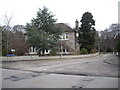
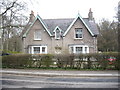
6
An elegant town residence
Deveron Road, Huntly.
Image: © Stanley Howe
Taken: 24 Apr 2010
0.06 miles
8
A villa on Deveron Road (A920)
Huntly.
Image: © Stanley Howe
Taken: 27 Aug 2013
0.07 miles
9
Deveron House Group building
Deveron Road, Huntly.
Image: © Stanley Howe
Taken: 24 Apr 2010
0.07 miles
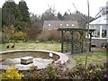
10
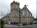
Family Centre -Deveron Road
Former drill hall for the volunteers of the Gordon Highlanders and drill station for the 2nd Scottish Horse.
Image: © John M
Taken: 3 Sep 2017
0.07 miles