IMAGES TAKEN NEAR TO
Kinnoir, HUNTLY, AB54 7YS
Introduction
This page details the photographs taken nearby to AB54 7YS by members of the Geograph project.
The Geograph project started in 2005 with the aim of publishing, organising and preserving representative images for every square kilometre of Great Britain, Ireland and the Isle of Man.

There are currently over 7.5m images from over14,400 individuals and you can help contribute to the project by visiting https://www.geograph.org.uk
Image Map
Images are licensed for reuse under creativecommons.org/licenses/by-sa/2.0
Notes
- Clicking on the map will re-center to the selected point.
- The higher the marker number, the further away the image location is from the centre of the postcode.
Image Listing (3 Images Found)
Images are licensed for reuse under creativecommons.org/licenses/by-sa/2.0
Image
Details
Distance
1
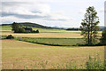
View from Auchmill to Kinnoir
Most of these fields have been cut for hay or silage. The Burn of Auchmull follows the field boundaries from right to left across this scene.
Image: © Anne Burgess
Taken: 18 Jun 2014
0.12 miles
2
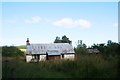
Old Cottage by Kinnoir
An old derelict cottage amidst roadside trees by Kinnoir.
Image: © Andrew Wood
Taken: 17 Aug 2011
0.24 miles
3
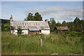
Abandoned Cottage
I have not found a name for this cottage, which has clearly not been lived in for some years. Compare Image], taken three years earlier. Even the trees are still the same shape! Though the one beside the door has grown quite a bit.
Image: © Anne Burgess
Taken: 18 Jun 2014
0.24 miles