IMAGES TAKEN NEAR TO
Cobairdy, HUNTLY, AB54 7YB
Introduction
This page details the photographs taken nearby to AB54 7YB by members of the Geograph project.
The Geograph project started in 2005 with the aim of publishing, organising and preserving representative images for every square kilometre of Great Britain, Ireland and the Isle of Man.

There are currently over 7.5m images from over14,400 individuals and you can help contribute to the project by visiting https://www.geograph.org.uk
Image Map
Images are licensed for reuse under creativecommons.org/licenses/by-sa/2.0
Notes
- Clicking on the map will re-center to the selected point.
- The higher the marker number, the further away the image location is from the centre of the postcode.
Image Listing (6 Images Found)
Images are licensed for reuse under creativecommons.org/licenses/by-sa/2.0
Image
Details
Distance
1
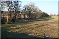
Burn of Cobairdy
The burn flows along the edge of the nearest field, it course marked by the trees. Beyond the trees there is a glimpse of Hallhill Crofts.
Image: © Anne Burgess
Taken: 11 Feb 2015
0.16 miles
2
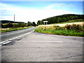
Crofts of Cruchie
The Crofts lies just beside the A97, with no opportunity of stopping to examine the curious wooden tower to the left of the house, beside the polytunnel.
Image: © Anne Burgess
Taken: 11 Feb 2015
0.21 miles
3
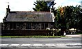
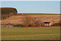
A cottage by the A97
Croft of Cruchie.
Image: © Stanley Howe
Taken: 20 Sep 2008
0.21 miles
4
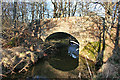
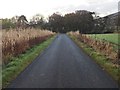
Stockie Bridge
The bridge carries a minor road over the Burn of Cobairdy.
Image: © Anne Burgess
Taken: 11 Feb 2015
0.22 miles