IMAGES TAKEN NEAR TO
Inverkeithny, HUNTLY, AB54 7XB
Introduction
This page details the photographs taken nearby to AB54 7XB by members of the Geograph project.
The Geograph project started in 2005 with the aim of publishing, organising and preserving representative images for every square kilometre of Great Britain, Ireland and the Isle of Man.

There are currently over 7.5m images from over14,400 individuals and you can help contribute to the project by visiting https://www.geograph.org.uk
Image Map
Images are licensed for reuse under creativecommons.org/licenses/by-sa/2.0
Notes
- Clicking on the map will re-center to the selected point.
- The higher the marker number, the further away the image location is from the centre of the postcode.
Image Listing (27 Images Found)
Images are licensed for reuse under creativecommons.org/licenses/by-sa/2.0
Image
Details
Distance
1
Country road, looking toward Inverkeithny
Image: © Steven Brown
Taken: 23 Jan 2008
0.02 miles
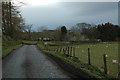
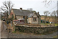
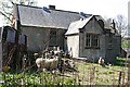
2
Cottages in Inverkeithny
Like the school and library across the road, these cottages look abandoned, as do the farm buildings beyond.
Image: © Anne Burgess
Taken: 27 Feb 2015
0.05 miles
3
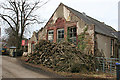
Inverkeithny School
The style of the building immediately tells me that it was originally a school, and this is confirmed by the second edition of the six-inch Ordnance Survey map. The panel above the window bears the date 1910.
Image: © Anne Burgess
Taken: 27 Feb 2015
0.07 miles
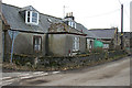
4
County Library
Although it bears the old-style torch logo of the library service, it has clearly not been in use as such for a long time.
Image: © Anne Burgess
Taken: 27 Feb 2015
0.07 miles
5
Old School
The style of the building immediately tells me that it was originally a school, and this is confirmed by the second edition of the six-inch Ordnance Survey map. The panel above the window bears the date 1910.
Image: © Anne Burgess
Taken: 27 Feb 2015
0.07 miles
6
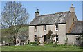
Old Schoolhouse
Seen from the main road which passes through the kirkton of Inverkeithy. This house is clearly much older than the school next door; it probably dates from the 18th century.
Image: © Anne Burgess
Taken: 9 May 2008
0.08 miles
7
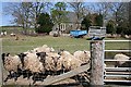
Where's Our Dinner?
As I paused here the sheep came running towards me, almost certainly in the hope that I was about to feed them.
Image: © Anne Burgess
Taken: 9 May 2008
0.08 miles
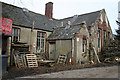
8
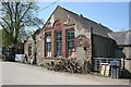
Inverkeithny School
The date above the middle window is 1910, so the building can only have been in use as a school for about half a century.
Image: © Anne Burgess
Taken: 9 May 2008
0.08 miles
9
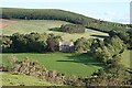
Inverkeithny Kirk
The kirk stands among the fields by the River Deveron; the road passes among the trees to the south. The river is hidden from view here at the foot of the slope below the straggly whins.
Image: © Anne Burgess
Taken: 29 Jun 2007
0.08 miles
10
Inverkeithny School
Local knowledge says that this school has been out of use as such for over 40 years.
Image: © Anne Burgess
Taken: 9 May 2008
0.08 miles