1
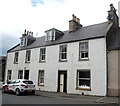
Former United Presbyterian Church, Cornhill Road, Aberchirder
Dating from ca. 1890, it became redundant as soon as 1900 when the UPs and the Frees merged. It was later a petrol station and then fell into dereliction, but it now (July 2017) being renovated, presumably as housing.
Image: © Bill Harrison
Taken: 1 Jul 2017
0.02 miles
2
North Street
Aberchirder is typical of an 18th century planned village, with straight streets and the houses parallel to the street, their doors opening straight on to the pavement.
Image: © Anne Burgess
Taken: 27 Feb 2008
0.03 miles
3
Terraced cottages, North Street, Aberchirder
Image: © Bill Harrison
Taken: 1 Jul 2017
0.05 miles
4
Main Street, Aberchirder
The scene west of the Square. Note the independent petrol station to the right and the derelict house opposite.
Image: © Bill Harrison
Taken: 1 Jul 2017
0.07 miles
5
Aberchirder - Rainy Foggie
"When Alexander Gordon, the laird of Auchintoul, decided in 1764 to found a planned village he selected a spot at the south end of Auchintoul Moss. Here there was a fermtoun called Foggieloan (from two Gaelic words foidh (peat moss) and lòn (meadow), so Foggieloan means peaty or boggy meadow), so he gave his village the same name".
www.foggieloan.co.uk
Image: © Colin Smith
Taken: 6 Jul 2024
0.07 miles
6
The auld bank, Aberchirder
The North of Scotland bank with agent's house next door opened in 1838 and is B-listed: http://portal.historicenvironment.scot/designation/LB19913 . It went through various name changes and became the Clydesdale around 1963. More recently, Clydesdale have been especially ruthless in closing rural branches in Scotland and villagers now have to travel to Banff (12 km) or Huntly (15 km) to conduct business.
Image: © Bill Harrison
Taken: 1 Jul 2017
0.08 miles
7
Main Street, Aberchirder
The shop on the immediate left is a pharmacy, newsagent and post office. Aberchirder was founded in 1764 by Alexander Gordon, Laird of Auchintoul, as a planned town on a grid pattern. He named it Aberchirder, but locals still use the old name Foggieloan, or just Foggie. See http://www.foggieloan.co.uk/43foundation/foundation.htm for more details of the history.
Image: © Stephen McKay
Taken: 28 May 2011
0.08 miles
8
Aberchirder pharmacy and post office
The village has most facilities, with the notable exception of a bank.
Image: © Bill Harrison
Taken: 1 Jul 2017
0.09 miles
9
Aberchirder Square
One corner of Aberchirder's spacious central square.
Image: © Stephen McKay
Taken: 28 May 2011
0.09 miles
10
Main Street, Aberchirder
Aberchirder is the only significant settlement on the road (the A97) between Banff and Huntly. It is a fine example of an 18th Century Scottish planned (or improvement) village built on a rational grid pattern (compare Strichen and New Pitsligo). It was established by Alexander Gordon in 1764, to provide some stimulus to help the area recover from the economic devastation of the Forty-Five. The three main streets [North Street, Main Street (pictured) and South Street] run roughly east-west and are dead straight but certainly not level.
Image: © Bill Harrison
Taken: 1 Jul 2017
0.10 miles


