IMAGES TAKEN NEAR TO
Bridge Of Marnoch, HUNTLY, AB54 7RY
Introduction
This page details the photographs taken nearby to AB54 7RY by members of the Geograph project.
The Geograph project started in 2005 with the aim of publishing, organising and preserving representative images for every square kilometre of Great Britain, Ireland and the Isle of Man.

There are currently over 7.5m images from over14,400 individuals and you can help contribute to the project by visiting https://www.geograph.org.uk
Image Map
Images are licensed for reuse under creativecommons.org/licenses/by-sa/2.0
Notes
- Clicking on the map will re-center to the selected point.
- The higher the marker number, the further away the image location is from the centre of the postcode.
Image Listing (3 Images Found)
Images are licensed for reuse under creativecommons.org/licenses/by-sa/2.0
Image
Details
Distance
1
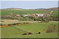
Longhaugh Farm from near Wardwell
Longhaugh is on the opposite bank of the River Deveron. A haugh is flat land beside a river, and it's not hard to see why several of the farms around here have haugh as part of their names.
Image: © Anne Burgess
Taken: 9 May 2008
0.07 miles
2
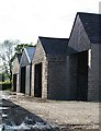
Longhaugh
Barn gables at Longhaugh Farm.
Image: © Anne Burgess
Taken: 29 Jun 2007
0.08 miles
3
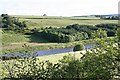
River Deveron
The view across the river from Longhaugh Farm.
Image: © Anne Burgess
Taken: 29 Jun 2007
0.18 miles