IMAGES TAKEN NEAR TO
Aberchirder, HUNTLY, AB54 7RE
Introduction
This page details the photographs taken nearby to AB54 7RE by members of the Geograph project.
The Geograph project started in 2005 with the aim of publishing, organising and preserving representative images for every square kilometre of Great Britain, Ireland and the Isle of Man.

There are currently over 7.5m images from over14,400 individuals and you can help contribute to the project by visiting https://www.geograph.org.uk
Image Map
Images are licensed for reuse under creativecommons.org/licenses/by-sa/2.0
Notes
- Clicking on the map will re-center to the selected point.
- The higher the marker number, the further away the image location is from the centre of the postcode.
Image Listing (7 Images Found)
Images are licensed for reuse under creativecommons.org/licenses/by-sa/2.0
Image
Details
Distance
1
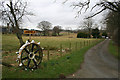
A farm relic of yesteryear on the lane to Janefield Farm.
Image: © Des Colhoun
Taken: 4 Mar 2007
0.03 miles


6

Old Milestone by the A97, south of Aberchirder, Marnoch parish
Stone post by the A97, in parish of Marnoch (District), 1 mile South of Aberchirder, at metal gate on hill down to bridge over Burn of Auchintoul, South side of road.
Inscription reads:-
10
(To Banff)
Surveyed
Milestone Society National ID: AD_BFHN10
Image: © Milestone Society
Taken: Unknown
0.21 miles
7
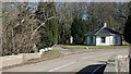
Bridge and Gatehouse at Auchintoul
The gatehouse is octagonal.
Image: © Anne Burgess
Taken: 27 Feb 2008
0.24 miles