IMAGES TAKEN NEAR TO
Aberchirder, HUNTLY, AB54 7QY
Introduction
This page details the photographs taken nearby to AB54 7QY by members of the Geograph project.
The Geograph project started in 2005 with the aim of publishing, organising and preserving representative images for every square kilometre of Great Britain, Ireland and the Isle of Man.

There are currently over 7.5m images from over14,400 individuals and you can help contribute to the project by visiting https://www.geograph.org.uk
Image Map
Images are licensed for reuse under creativecommons.org/licenses/by-sa/2.0
Notes
- Clicking on the map will re-center to the selected point.
- The higher the marker number, the further away the image location is from the centre of the postcode.
Image Listing (2 Images Found)
Images are licensed for reuse under creativecommons.org/licenses/by-sa/2.0
Image
Details
Distance
1
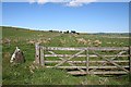
Battlefield
I have no idea why this croft is named Battlefield. There isn't any indication on the maps that there was ever a historical battle here.
Image: © Anne Burgess
Taken: 14 May 2007
0.02 miles
2
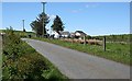
Springfield
As well as the original croft house here, which has been modernised, there are two new bungalows.
Image: © Anne Burgess
Taken: 14 May 2007
0.09 miles