IMAGES TAKEN NEAR TO
Aberchirder, HUNTLY, AB54 7QU
Introduction
This page details the photographs taken nearby to AB54 7QU by members of the Geograph project.
The Geograph project started in 2005 with the aim of publishing, organising and preserving representative images for every square kilometre of Great Britain, Ireland and the Isle of Man.

There are currently over 7.5m images from over14,400 individuals and you can help contribute to the project by visiting https://www.geograph.org.uk
Image Map
Images are licensed for reuse under creativecommons.org/licenses/by-sa/2.0
Notes
- Clicking on the map will re-center to the selected point.
- The higher the marker number, the further away the image location is from the centre of the postcode.
Image Listing (5 Images Found)
Images are licensed for reuse under creativecommons.org/licenses/by-sa/2.0
Image
Details
Distance
1
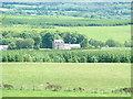
Crombie Castle seen from Brae of Crombie
Image: © Greg Stringham
Taken: 25 Jun 2005
0.03 miles
2
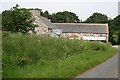
Mains of Crombie
This is part of the steading at Crombie Castle. It looks pretty derelict, but work is in progress to tidy it up, so perhaps it is going to be renovated.
Image: © Anne Burgess
Taken: 22 Jun 2007
0.03 miles
3
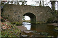
Bridge over the Crombie Burn by the castle.
Image: © Des Colhoun
Taken: 4 Mar 2007
0.04 miles
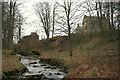
5

Crombie Burn
Looking upstream from the bridge at Burnervie. The large house to the left of the stream is Crombie Castle, which is in the next square.
Image: © Anne Burgess
Taken: 22 Jun 2007
0.24 miles