IMAGES TAKEN NEAR TO
Aberchirder, HUNTLY, AB54 7QT
Introduction
This page details the photographs taken nearby to AB54 7QT by members of the Geograph project.
The Geograph project started in 2005 with the aim of publishing, organising and preserving representative images for every square kilometre of Great Britain, Ireland and the Isle of Man.

There are currently over 7.5m images from over14,400 individuals and you can help contribute to the project by visiting https://www.geograph.org.uk
Image Map
Images are licensed for reuse under creativecommons.org/licenses/by-sa/2.0
Notes
- Clicking on the map will re-center to the selected point.
- The higher the marker number, the further away the image location is from the centre of the postcode.
Image Listing (3 Images Found)
Images are licensed for reuse under creativecommons.org/licenses/by-sa/2.0
Image
Details
Distance
2
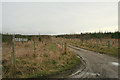
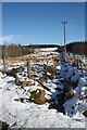
Clearing near Culvie
The road is lined on both sides by woodland, but this clearing, made for the power line, offers a view to the open land beyond. The ditch drains into the Culvie Burn.
Image: © Anne Burgess
Taken: 22 Feb 2010
0.11 miles
3
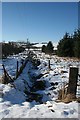
Drainage Ditch near Culvie
The ditch occupies part of a clearing made for the power lines, allowing a view up to the open land above.
Image: © Anne Burgess
Taken: 22 Feb 2010
0.19 miles