IMAGES TAKEN NEAR TO
Aberchirder, HUNTLY, AB54 7QJ
Introduction
This page details the photographs taken nearby to AB54 7QJ by members of the Geograph project.
The Geograph project started in 2005 with the aim of publishing, organising and preserving representative images for every square kilometre of Great Britain, Ireland and the Isle of Man.

There are currently over 7.5m images from over14,400 individuals and you can help contribute to the project by visiting https://www.geograph.org.uk
Image Map
Images are licensed for reuse under creativecommons.org/licenses/by-sa/2.0
Notes
- Clicking on the map will re-center to the selected point.
- The higher the marker number, the further away the image location is from the centre of the postcode.
Image Listing (3 Images Found)
Images are licensed for reuse under creativecommons.org/licenses/by-sa/2.0
Image
Details
Distance
2
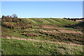
Glacial Meltwater Channel
This has all the classic hallmarks of a glacial meltwater channel - a wide sinuous valley far too big to have been created by the stream it contains. The boggy ground in the valley floor is also a common feature. The house at top left is Upper Peterden.
Image: © Anne Burgess
Taken: 1 Nov 2011
0.07 miles