IMAGES TAKEN NEAR TO
Aberchirder, HUNTLY, AB54 7QH
Introduction
This page details the photographs taken nearby to AB54 7QH by members of the Geograph project.
The Geograph project started in 2005 with the aim of publishing, organising and preserving representative images for every square kilometre of Great Britain, Ireland and the Isle of Man.

There are currently over 7.5m images from over14,400 individuals and you can help contribute to the project by visiting https://www.geograph.org.uk
Image Map
Images are licensed for reuse under creativecommons.org/licenses/by-sa/2.0
Notes
- Clicking on the map will re-center to the selected point.
- The higher the marker number, the further away the image location is from the centre of the postcode.
Image Listing (12 Images Found)
Images are licensed for reuse under creativecommons.org/licenses/by-sa/2.0
Image
Details
Distance
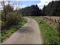
1
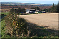
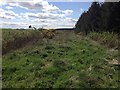
Looking towards Peterden
The maps seem less than unanimous about where the gridline is. The 1:50,000 suggest that the house is in this square, but the 1:25,000 suggests it is just in the next square. The foreground, however, is all in this square.
Image: © Anne Burgess
Taken: 1 Nov 2011
0.04 miles
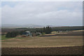
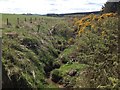
6
Reidside Burn and houses at Cormickhillock
Image: © Des Colhoun
Taken: 5 Mar 2007
0.18 miles
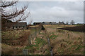
10
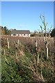
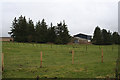
Cormackhillock Cottage
The cottage, quite a modern building, is just beside the minor road, with a wild scrubby damp area just outside the neatly tended garden.
Image: © Anne Burgess
Taken: 1 Nov 2011
0.20 miles