IMAGES TAKEN NEAR TO
Aberchirder, HUNTLY, AB54 7QF
Introduction
This page details the photographs taken nearby to AB54 7QF by members of the Geograph project.
The Geograph project started in 2005 with the aim of publishing, organising and preserving representative images for every square kilometre of Great Britain, Ireland and the Isle of Man.

There are currently over 7.5m images from over14,400 individuals and you can help contribute to the project by visiting https://www.geograph.org.uk
Image Map
Images are licensed for reuse under creativecommons.org/licenses/by-sa/2.0
Notes
- Clicking on the map will re-center to the selected point.
- The higher the marker number, the further away the image location is from the centre of the postcode.
Image Listing (4 Images Found)
Images are licensed for reuse under creativecommons.org/licenses/by-sa/2.0
Image
Details
Distance
1
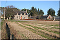
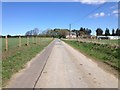
Auchinderran
A neat stone farmhouse with a southerly aspect. Note the porch with finials.
Image: © Anne Burgess
Taken: 1 Nov 2011
0.01 miles
4
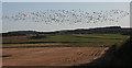
Wild Geese at Auchinderran
Several hundred geese wheel over a stubble field at Auchinderran. I think they are Pink-Footed Geese, and they are on their autumn passage south from their breeding grounds in the Arctic.
Image: © Anne Burgess
Taken: 1 Nov 2011
0.22 miles