IMAGES TAKEN NEAR TO
Aberchirder, HUNTLY, AB54 7PR
Introduction
This page details the photographs taken nearby to AB54 7PR by members of the Geograph project.
The Geograph project started in 2005 with the aim of publishing, organising and preserving representative images for every square kilometre of Great Britain, Ireland and the Isle of Man.

There are currently over 7.5m images from over14,400 individuals and you can help contribute to the project by visiting https://www.geograph.org.uk
Image Map
Images are licensed for reuse under creativecommons.org/licenses/by-sa/2.0
Notes
- Clicking on the map will re-center to the selected point.
- The higher the marker number, the further away the image location is from the centre of the postcode.
Image Listing (2 Images Found)
Images are licensed for reuse under creativecommons.org/licenses/by-sa/2.0
Image
Details
Distance
1
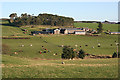
Craigiebrae
Rather worryingly, Craigiebrae doesn't look anything like the images captioned Craigiebrae Farm which have already been submitted for the next square to the west Image I suspect confusion arising from the placing of the name on the 1:50,000 map; further investigation will be needed.
Image: © Anne Burgess
Taken: 1 Nov 2011
0.02 miles
2
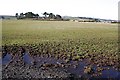
Field at Craigiebrae
The roofs of Craigiebrae are just visible to the right of the clump of trees.
Image: © Anne Burgess
Taken: 27 Feb 2008
0.13 miles