IMAGES TAKEN NEAR TO
Anderson Drive, HUNTLY, AB54 7NF
Introduction
This page details the photographs taken nearby to Anderson Drive, AB54 7NF by members of the Geograph project.
The Geograph project started in 2005 with the aim of publishing, organising and preserving representative images for every square kilometre of Great Britain, Ireland and the Isle of Man.

There are currently over 7.5m images from over14,400 individuals and you can help contribute to the project by visiting https://www.geograph.org.uk
Image Map
Images are licensed for reuse under creativecommons.org/licenses/by-sa/2.0
Notes
- Clicking on the map will re-center to the selected point.
- The higher the marker number, the further away the image location is from the centre of the postcode.
Image Listing (39 Images Found)
Images are licensed for reuse under creativecommons.org/licenses/by-sa/2.0
Image
Details
Distance
1
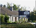
Old-style Road Sign
There are not very many of these signs left now.
Image: © Anne Burgess
Taken: 8 Oct 2008
0.04 miles
2
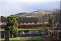
Milltown of Rothiemay
Having left our car beside a sign saying that the parking area (the only one in the village) is for visitors to the cemetery, we felt obliged to visit the cemetery when we returned from our walk. This was far from being a hardship, because as well as some interesting gravestones there is a bench which offered us this view while we relaxed in the sunshine with the second instalment of our picnic. (The three cars in view were all there when we first arrived, and still there when we left to go home, but we saw no-one else visiting the cemetery.) On the skyline is Fourman Hill, and our seven-mile walk had taken us over the shoulder of the hill past the scattered trees.
Image: © Anne Burgess
Taken: 4 Feb 2022
0.15 miles

5
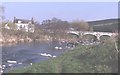
Rothiemay Bridge
The village of Milltown of Rothiemay lies on the left bank of the River Deveron, and is the only road crossing point between Huntly and Bridge of Marnoch.
Image: © Anne Burgess
Taken: Unknown
0.18 miles
6
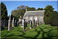
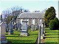
Rothiemay Parish Kirk
The modest parish kirk stands just west of the road into Rothiemay from the north. Both kirk and graveyard are still in use. The kirk dates from 1807, and stone from the earlier church, St Dunstan's, was used when it was built. The pulpit is in the middle of the south wall with pews and galleries facing it.
Image: © Anne Burgess
Taken: 8 Oct 2008
0.18 miles
7
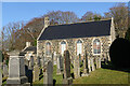
Rothiemay Parish Kirk
The kirk dates from 1807 and is a Category B Listed building. It incorporates some features from earlier buildings. See http://portal.historicenvironment.scot/designation/LB15616 for more details.
Image: © Anne Burgess
Taken: 4 Feb 2022
0.19 miles
8

Rothiemay Kirk
The parish church at Rothiemay.
Image: © Andrew Wood
Taken: 17 Aug 2011
0.19 miles
9
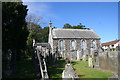
Kirk and Kirkyard
Rothiemay parish church and churchyard.
Image: © Andrew Wood
Taken: 17 Aug 2011
0.19 miles