IMAGES TAKEN NEAR TO
Rothiemay, HUNTLY, AB54 7NA
Introduction
This page details the photographs taken nearby to AB54 7NA by members of the Geograph project.
The Geograph project started in 2005 with the aim of publishing, organising and preserving representative images for every square kilometre of Great Britain, Ireland and the Isle of Man.

There are currently over 7.5m images from over14,400 individuals and you can help contribute to the project by visiting https://www.geograph.org.uk
Image Map
Images are licensed for reuse under creativecommons.org/licenses/by-sa/2.0
Notes
- Clicking on the map will re-center to the selected point.
- The higher the marker number, the further away the image location is from the centre of the postcode.
Image Listing (7 Images Found)
Images are licensed for reuse under creativecommons.org/licenses/by-sa/2.0
Image
Details
Distance
1
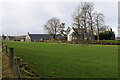
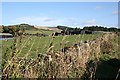
Corsekellie Farm
Corskellie lies astride the minor road, with outbuildings on both sides. These are the buildings on the north side, closer to the River Deveron.
Image: © Anne Burgess
Taken: 4 Feb 2022
0.03 miles
2
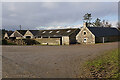
Corskellie Farm
Some of the extensive range of traditional stone buildings on the north side of the minor road.
Image: © Anne Burgess
Taken: 4 Feb 2022
0.04 miles
3
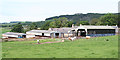
Corskellie
There are extensive farm buildings at Corskellie, the older byres surrounded by more modern cattle courts.
Image: © Anne Burgess
Taken: 18 Jun 2014
0.06 miles
4
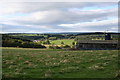
Corskellie Farm by the banks of the Deveron
Image: © Des Colhoun
Taken: 8 Oct 2006
0.11 miles
5
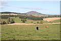
Corsskellie
There are two blocks of barns at Corskellie. This is the more easterly group. In the background is Gallow Hill.
Image: © Anne Burgess
Taken: 8 Oct 2008
0.12 miles
6
Looking Towards Knock Hill from Corskellie
Though the foreground is all in square, the dominating feature of the landscape is the shapely Knock Hill, several miles to the north.
Image: © Anne Burgess
Taken: 8 Oct 2008
0.21 miles
7
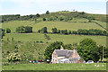
Haickburn Cottage
Notwithstanding the fact that the 1:25,000 map labels this Corskellie Cottages, this is Haickburn Cottage, as shown on the old maps and the sign at the gate. My thanks to Ian Godfrey for clarifying the matter. Let's hope the OS manages to correct the 1:25,000 map! Gallow Hill is in the background, and the line of trees on the slope up to it is the B9117 from Rothiemay to Bridge of Marnoch (or vice versa).
Image: © Anne Burgess
Taken: 18 Jun 2014
0.21 miles