IMAGES TAKEN NEAR TO
Knock, HUNTLY, AB54 7LS
Introduction
This page details the photographs taken nearby to AB54 7LS by members of the Geograph project.
The Geograph project started in 2005 with the aim of publishing, organising and preserving representative images for every square kilometre of Great Britain, Ireland and the Isle of Man.

There are currently over 7.5m images from over14,400 individuals and you can help contribute to the project by visiting https://www.geograph.org.uk
Image Map
Images are licensed for reuse under creativecommons.org/licenses/by-sa/2.0
Notes
- Clicking on the map will re-center to the selected point.
- The higher the marker number, the further away the image location is from the centre of the postcode.
Image Listing (6 Images Found)
Images are licensed for reuse under creativecommons.org/licenses/by-sa/2.0
Image
Details
Distance
1
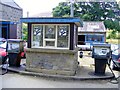
The Garage at Glenbarry
These pumps are rather dated and only dispense diesel, no petrol
is sold at this garage.The garage has been run for many years by the same family.
Image: © Ann Harrison
Taken: 14 Aug 2008
0.11 miles
2
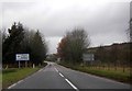
Glenbarry
On the right is the signpost at the approach on the B9022 to the junction with the A95 at Glenbarry. The trees mark the line of the long-disused railway which once ran from Keith to Banff.
Image: © Anne Burgess
Taken: 22 Feb 2010
0.21 miles
5
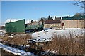
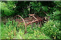
Collapsed Building
Was this, I wonder, one of the many buildings which collapsed under the weight of snow in January 2010?
Image: © Anne Burgess
Taken: 22 Feb 2010
0.24 miles