IMAGES TAKEN NEAR TO
Knock, HUNTLY, AB54 7LN
Introduction
This page details the photographs taken nearby to AB54 7LN by members of the Geograph project.
The Geograph project started in 2005 with the aim of publishing, organising and preserving representative images for every square kilometre of Great Britain, Ireland and the Isle of Man.

There are currently over 7.5m images from over14,400 individuals and you can help contribute to the project by visiting https://www.geograph.org.uk
Image Map
Images are licensed for reuse under creativecommons.org/licenses/by-sa/2.0
Notes
- Clicking on the map will re-center to the selected point.
- The higher the marker number, the further away the image location is from the centre of the postcode.
Image Listing (7 Images Found)
Images are licensed for reuse under creativecommons.org/licenses/by-sa/2.0
Image
Details
Distance
1
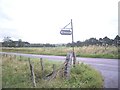
Signpost for Netherton
By B9022, between Clovenstone and Knabbygates Bridge.
Image: © Stanley Howe
Taken: 30 Aug 2012
0.09 miles
2
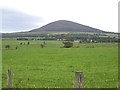
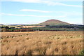
View to Knock Hill
From B9022 at Netherton junction.
Image: © Stanley Howe
Taken: 30 Aug 2012
0.09 miles
3
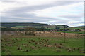
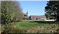
Looking across the Rowan Bauds towards Netherton
Image: © Des Colhoun
Taken: 9 Oct 2006
0.12 miles
4
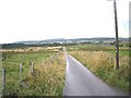
Access lane to Netherton of Knock
From B9022.
Image: © Stanley Howe
Taken: 30 Aug 2012
0.14 miles
5
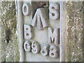
Ordnance Survey Flush Bracket G938
This can be found on Knabbygates Bridge.
For more detail see : http://www.bench-marks.org.uk/bm16954
Image: © Peter Wood
Taken: 4 Oct 2012
0.19 miles
7
Knabbygates
According to the 1:25,000 map the north-south gridline runs through the middle of this farm.
Image: © Anne Burgess
Taken: 30 Apr 2007
0.25 miles