IMAGES TAKEN NEAR TO
Aucharnie Place, HUNTLY, AB54 6JQ
Introduction
This page details the photographs taken nearby to Aucharnie Place, AB54 6JQ by members of the Geograph project.
The Geograph project started in 2005 with the aim of publishing, organising and preserving representative images for every square kilometre of Great Britain, Ireland and the Isle of Man.

There are currently over 7.5m images from over14,400 individuals and you can help contribute to the project by visiting https://www.geograph.org.uk
Image Map
Images are licensed for reuse under creativecommons.org/licenses/by-sa/2.0
Notes
- Clicking on the map will re-center to the selected point.
- The higher the marker number, the further away the image location is from the centre of the postcode.
Image Listing (6 Images Found)
Images are licensed for reuse under creativecommons.org/licenses/by-sa/2.0
Image
Details
Distance
1
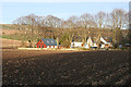
Near Aucharnie
After an overcast afternoon, the sun has emerged to illuminate these houses near Aucharnie, which are not named on the maps.
Image: © Anne Burgess
Taken: 4 Mar 2015
0.06 miles
2
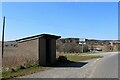
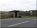
Bus Shelter by Auchaber Road
A bus shelter by the junction on the Auchaber road and the B9001 by Largue.
Image: © Andrew Wood
Taken: 17 Apr 2021
0.13 miles
3
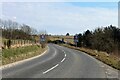
Slow For Largue
Speed signs on the B9001 as it enters Largue from the west.
Image: © Andrew Wood
Taken: 17 Apr 2021
0.14 miles
5
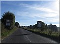
Alight here for church
Bus shelter on the B9001.
Image: © James Allan
Taken: 30 Nov 2006
0.18 miles
6
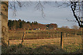
Looking towards Nether Aucharnie
The farm buildings at Nether Aucharnie are hidden from view by the trees and the lie of the land. The houses are beside the access road to the farm.
Image: © Anne Burgess
Taken: 4 Mar 2015
0.22 miles