IMAGES TAKEN NEAR TO
HUNTLY, AB54 6JN
Introduction
This page details the photographs taken nearby to AB54 6JN by members of the Geograph project.
The Geograph project started in 2005 with the aim of publishing, organising and preserving representative images for every square kilometre of Great Britain, Ireland and the Isle of Man.

There are currently over 7.5m images from over14,400 individuals and you can help contribute to the project by visiting https://www.geograph.org.uk
Image Map
Images are licensed for reuse under creativecommons.org/licenses/by-sa/2.0
Notes
- Clicking on the map will re-center to the selected point.
- The higher the marker number, the further away the image location is from the centre of the postcode.
Image Listing (5 Images Found)
Images are licensed for reuse under creativecommons.org/licenses/by-sa/2.0
Image
Details
Distance
1
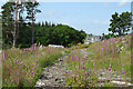
Old Forest Track
The track must have been used when the forest on Brunstane Hill was felled, but is now reverting to nature. The house is at Hillhead of Affleck.
Image: © Anne Burgess
Taken: 19 Jul 2021
0.03 miles
2
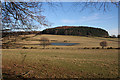
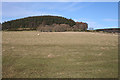
Hill of Brunstane
Hill of Brunstane is the small round hill with a forest plantation on it. The pond does not appear on any of the maps and is probably ephemeral.
Image: © Anne Burgess
Taken: 11 Feb 2015
0.15 miles
3
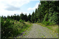
Forest Road
This road skirts the edge of the Wood of Kinnoir.
Image: © Anne Burgess
Taken: 19 Jul 2021
0.16 miles
4
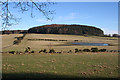
Hill of Bruntstane
A stile just out of view on the left gives access to a path following the line of the field boundary on the left up to the left edge of the forest plantation on Hill of Bruntstane, also spelled Brunstane.
Image: © Anne Burgess
Taken: 11 Feb 2015
0.18 miles
5
Upper Bruntstane
Somewhere among the birches on the flanks of the Hill of Brunstane, also spelled Bruntstane, are the buildings of Upper Bruntstane, or at least what remains of them.
Image: © Anne Burgess
Taken: 11 Feb 2015
0.22 miles