IMAGES TAKEN NEAR TO
Aberdeen Road, HUNTLY, AB54 6JE
Introduction
This page details the photographs taken nearby to Aberdeen Road, AB54 6JE by members of the Geograph project.
The Geograph project started in 2005 with the aim of publishing, organising and preserving representative images for every square kilometre of Great Britain, Ireland and the Isle of Man.

There are currently over 7.5m images from over14,400 individuals and you can help contribute to the project by visiting https://www.geograph.org.uk
Image Map
Images are licensed for reuse under creativecommons.org/licenses/by-sa/2.0
Notes
- Clicking on the map will re-center to the selected point.
- The higher the marker number, the further away the image location is from the centre of the postcode.
Image Listing (30 Images Found)
Images are licensed for reuse under creativecommons.org/licenses/by-sa/2.0
Image
Details
Distance
1
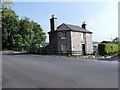
Former tollhouse
Surveyed by the Milestone Society. This building is on the A97 eastwards out of Huntly at the junction with Old Toll Road east of the railway station. It is now called Rose Cottage. There are windows on the far side of the protruding front so good views up and down the road.
Image: © Chris Minto
Taken: 19 May 2014
0.08 miles
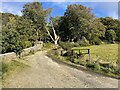
6
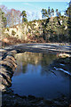
Quarry in Battlehill
This looks to me very like a disused quarry, which presumably exploited the igneous intrusive gabbro and norite formed here by intrusions of silica-poor magma approximately 444 to 488 million years ago in the Ordovician Period.
However the information board says it is an events area. I hope they can manage to drain it if they plan to hold events in it!
Image: © Anne Burgess
Taken: 11 Feb 2015
0.16 miles
7
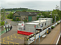
Former goods shed at Huntly station
A rare survival from the days when nearly every country station had its good sidings and shed. See also Image Its present use is unclear. The portable buildings in the foreground were associated with the upgrade of the railway between Inverness and Aberdeen.
Image: © Stephen Craven
Taken: 4 Jul 2019
0.17 miles
9
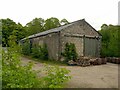
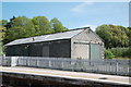
Huntly Station ? former goods shed
Typical Great North of Scotland Railway building using the traditional stonework using rectangular blocks with small infill strips.
Image: © Alan Murray-Rust
Taken: 20 May 2022
0.17 miles
10
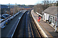
Railway Station
I had had it in mind for some time to attempt to duplicate Image], taken 18 years earlier, and today was when I finally remembered to do something about it. The buildings on the left have gone altogether, and the one on the right has been replaced by a modern one. The sheds in the distance look much the same, but scrubby vegetation is beginning to grow up in front of them.
Image: © Anne Burgess
Taken: 11 Feb 2015
0.18 miles