IMAGES TAKEN NEAR TO
HUNTLY, AB54 6JD
Introduction
This page details the photographs taken nearby to AB54 6JD by members of the Geograph project.
The Geograph project started in 2005 with the aim of publishing, organising and preserving representative images for every square kilometre of Great Britain, Ireland and the Isle of Man.

There are currently over 7.5m images from over14,400 individuals and you can help contribute to the project by visiting https://www.geograph.org.uk
Image Map
Images are licensed for reuse under creativecommons.org/licenses/by-sa/2.0
Notes
- Clicking on the map will re-center to the selected point.
- The higher the marker number, the further away the image location is from the centre of the postcode.
Image Listing (9 Images Found)
Images are licensed for reuse under creativecommons.org/licenses/by-sa/2.0
Image
Details
Distance
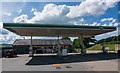
1
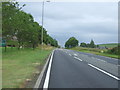
A96 filling station
Petrol station on the A96 east of Huntly.
Image: © James Allan
Taken: 30 Nov 2006
0.02 miles
2
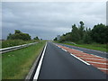
Petrol station east of Huntly on the A96
Image: © Peter Moore
Taken: 19 Jul 2016
0.05 miles
3
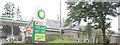
BP filling station on A96/A97 near Huntly
Image: © Stanley Howe
Taken: 13 Aug 2012
0.06 miles
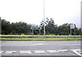
4
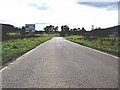
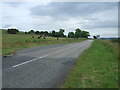
Major road junction
Where A97 joins the Aberdeen to Inverness trunk road (A96), outside Huntly.
Image: © Stanley Howe
Taken: 20 Sep 2008
0.12 miles