IMAGES TAKEN NEAR TO
Corse, HUNTLY, AB54 6HW
Introduction
This page details the photographs taken nearby to AB54 6HW by members of the Geograph project.
The Geograph project started in 2005 with the aim of publishing, organising and preserving representative images for every square kilometre of Great Britain, Ireland and the Isle of Man.

There are currently over 7.5m images from over14,400 individuals and you can help contribute to the project by visiting https://www.geograph.org.uk
Image Map
Images are licensed for reuse under creativecommons.org/licenses/by-sa/2.0
Notes
- Clicking on the map will re-center to the selected point.
- The higher the marker number, the further away the image location is from the centre of the postcode.
Image Listing (4 Images Found)
Images are licensed for reuse under creativecommons.org/licenses/by-sa/2.0
Image
Details
Distance
1
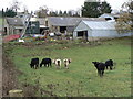
No colour prejudice here
Black and white cattle, with Mains of Frendraught farm in the background.
Image: © James Allan
Taken: 30 Nov 2006
0.07 miles
2
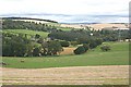
Frendraught
Frendraught House can be seen half-hidden among the trees, and the complex of buildings at centre left is Mains of Frendraught.
Image: © Anne Burgess
Taken: 19 Sep 2008
0.12 miles
3
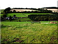
Stock feeders on Frendraught estate
With South Mains of Frendraught across the stream.
Image: © Stanley Howe
Taken: 20 Sep 2007
0.13 miles
4
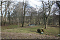
Shady Pond
A small pond in a narrow strip of trees, fed by an unnamed burn coming down from Colyne.
Image: © Anne Burgess
Taken: 4 Mar 2015
0.20 miles