IMAGES TAKEN NEAR TO
Ythanwells, HUNTLY, AB54 6HB
Introduction
This page details the photographs taken nearby to AB54 6HB by members of the Geograph project.
The Geograph project started in 2005 with the aim of publishing, organising and preserving representative images for every square kilometre of Great Britain, Ireland and the Isle of Man.

There are currently over 7.5m images from over14,400 individuals and you can help contribute to the project by visiting https://www.geograph.org.uk
Image Map
Images are licensed for reuse under creativecommons.org/licenses/by-sa/2.0
Notes
- Clicking on the map will re-center to the selected point.
- The higher the marker number, the further away the image location is from the centre of the postcode.
Image Listing (2 Images Found)
Images are licensed for reuse under creativecommons.org/licenses/by-sa/2.0
Image
Details
Distance
1
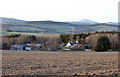
Lilybank
Looking a bit wan in the fading light, Lilybank stands at the corner of a field, sheltered by trees to the north. The prominent hill on the horizon is Knock Hill.
Image: © Anne Burgess
Taken: 10 Mar 2015
0.12 miles
2
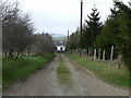
Lilybank
More conifers than lilies, but Lilybank it is called.
Image: © James Allan
Taken: 30 Nov 2006
0.14 miles