IMAGES TAKEN NEAR TO
Ythanwells, HUNTLY, AB54 6HA
Introduction
This page details the photographs taken nearby to AB54 6HA by members of the Geograph project.
The Geograph project started in 2005 with the aim of publishing, organising and preserving representative images for every square kilometre of Great Britain, Ireland and the Isle of Man.

There are currently over 7.5m images from over14,400 individuals and you can help contribute to the project by visiting https://www.geograph.org.uk
Image Map
Images are licensed for reuse under creativecommons.org/licenses/by-sa/2.0
Notes
- Clicking on the map will re-center to the selected point.
- The higher the marker number, the further away the image location is from the centre of the postcode.
Image Listing (14 Images Found)
Images are licensed for reuse under creativecommons.org/licenses/by-sa/2.0
Image
Details
Distance
1
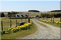
Lochmoss Croft
The daffodil lined entrance to Lochmoss Croft.
Image: © Andrew Wood
Taken: 17 Apr 2021
0.08 miles
2
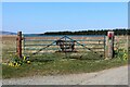
Lochmoss Croft Sign
The nicely visible sign to Lochmoss Croft placed on a gate in a field adjacent to the access.
Image: © Andrew Wood
Taken: 17 Apr 2021
0.12 miles
3
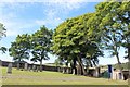
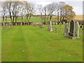
Ythanwells Cemetery
Roadside trees inside the cemetery at Ythanwells.
Image: © Andrew Wood
Taken: 16 Aug 2020
0.21 miles
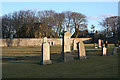
4
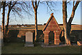
Memorial at Ythanwells
Curiously, I could not make out whom the sandstone arch commemorates. In the background is Lochmoss.
Image: © Anne Burgess
Taken: 10 Mar 2015
0.21 miles
5
Part of the cemetery at Ythanwell
Looking north-eastward.
Image: © Peter Wood
Taken: 26 Oct 2018
0.22 miles
6
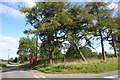
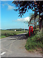
Ythanwells Phone and Crossroad
The telephone kiosk by the crossroads at Ythanwells.
Image: © Andrew Wood
Taken: 17 Aug 2011
0.22 miles
7
Ythanwells Cemetery
The cemetery at Ythanwells seems to be very thinly populated, with gravestones if not with buried coffins. It is not on the first edition six-inch map, but it is on the second edition, so it must date from the latter part of the 19th century. In the trees beyond is the kirk, which is in a state of dilapidation, and looks as if it had been used as a barn.
Image: © Anne Burgess
Taken: 10 Mar 2015
0.23 miles
8
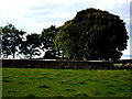
Ythanwells cemetery
The enclosure wall seen from near Ythanwells crossroads.
Image: © Stanley Howe
Taken: 20 Sep 2007
0.23 miles
9
Phone or Post
Telephone box & Postbox at the Ythanwells crossroads.
Image: © Andrew Stuart
Taken: 21 Jun 2007
0.24 miles
10
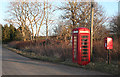
Traditional Communications
Ythan Wells is quite unusual. It has a kirk, manse, cemetery, school, phone box and post box, but no village to speak of. Admittedly the kirk is derelict (and unphotographable at this time of day) and the manse was sold off years ago, but still, it's a bit ironic, when many places that are villages are losing those very amenities.
Image: © Anne Burgess
Taken: 10 Mar 2015
0.24 miles