IMAGES TAKEN NEAR TO
HUNTLY, AB54 6EU
Introduction
This page details the photographs taken nearby to AB54 6EU by members of the Geograph project.
The Geograph project started in 2005 with the aim of publishing, organising and preserving representative images for every square kilometre of Great Britain, Ireland and the Isle of Man.

There are currently over 7.5m images from over14,400 individuals and you can help contribute to the project by visiting https://www.geograph.org.uk
Image Map
Images are licensed for reuse under creativecommons.org/licenses/by-sa/2.0
Notes
- Clicking on the map will re-center to the selected point.
- The higher the marker number, the further away the image location is from the centre of the postcode.
Image Listing (8 Images Found)
Images are licensed for reuse under creativecommons.org/licenses/by-sa/2.0
Image
Details
Distance
1
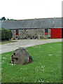
A collection of Mill Stones
Mill Stones at Troupsmill farm.
Image: © Andrew Stuart
Taken: 9 Jun 2007
0.03 miles
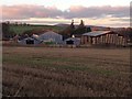
3

Troupsmill
Troupsmill is in the middle distance, with Loanhead above it and the Hill of Newtongarry is on the skyline.
Image: © Anne Burgess
Taken: 10 Mar 2015
0.06 miles
4
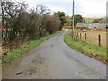
Minor road approaching Troupsmill
Looking north-westward.
Image: © Peter Wood
Taken: 26 Oct 2018
0.07 miles
5
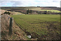
Above Kirkton Mill
Winter cereal in a field beside the road down to Kirkton Mill. The large barn in the middle distance is at Troupsmill.
Image: © Anne Burgess
Taken: 4 Mar 2015
0.13 miles
6
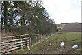
Shelter Belt
I surmise that this is more than just a shelter belt - it could be the march of two different farms.
Image: © Anne Burgess
Taken: 4 Mar 2015
0.19 miles
7
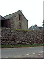
Kirktown Mill
Quite a drystone wall, I had a look and could not find any cement or mortar anywhere.
Image: © Andrew Stuart
Taken: 9 Jun 2007
0.19 miles
8
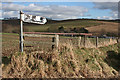
Outdated Sign
Neither Corse School nor Corse Post Office exists now, but I do expect to find the Wells of Ythan, though perhaps not today as there are plenty of nearer squares to explore.
Image: © Anne Burgess
Taken: 4 Mar 2015
0.24 miles