IMAGES TAKEN NEAR TO
Drumblade, HUNTLY, AB54 6EP
Introduction
This page details the photographs taken nearby to AB54 6EP by members of the Geograph project.
The Geograph project started in 2005 with the aim of publishing, organising and preserving representative images for every square kilometre of Great Britain, Ireland and the Isle of Man.

There are currently over 7.5m images from over14,400 individuals and you can help contribute to the project by visiting https://www.geograph.org.uk
Image Map
Images are licensed for reuse under creativecommons.org/licenses/by-sa/2.0
Notes
- Clicking on the map will re-center to the selected point.
- The higher the marker number, the further away the image location is from the centre of the postcode.
Image Listing (7 Images Found)
Images are licensed for reuse under creativecommons.org/licenses/by-sa/2.0
Image
Details
Distance
1
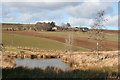
Woodbank
Looking across the Burn of Begshill to the farm of Woodbank, high up on the far side.
Image: © Anne Burgess
Taken: 10 Mar 2015
0.02 miles
2
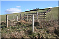
Hill of Comalegy
The double fence line contains a ditch that drains the fields on the slope of the Hill of Comalegy into the Burn of Drumblade.
Image: © Anne Burgess
Taken: 10 Mar 2015
0.20 miles
3
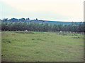
Remains of a Stone Circle
Only two stones from this circle remain. Standing stones and Stone Circles are quite common in this part of Aberdeenshire.
Image: © Andrew Stuart
Taken: 9 Jun 2007
0.22 miles
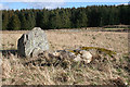
4
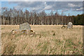
Stoneyfield Stone Circle (1)
Only these two stones remain standing out of a probable twelve that are thought to have formed a circle 12 to 14 metres in diameter. For full details see http://canmore.rcahms.gov.uk/en/site/17726/details/stoneyfield/. Image]
Image: © Anne Burgess
Taken: 10 Mar 2015
0.24 miles
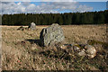
5
Stoneyfield Stone Circle (2)
This is the more westerly of the two stones still standing, with what are probably some of its fellows lying alongside it. See http://canmore.rcahms.gov.uk/en/site/17726/details/stoneyfield/ for a full description. Image]
Image: © Anne Burgess
Taken: 10 Mar 2015
0.24 miles
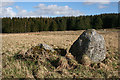
6
Stoneyfield Stone Circle (3)
The two standing stones are just two of, probably, twelve that made up the circle. Three were lost some time ago, and seven more were moved from where the stood and now lie in the grass beside their fellows. There is a full description at http://canmore.rcahms.gov.uk/en/site/17726/details/stoneyfield/. Image]
Image: © Anne Burgess
Taken: 10 Mar 2015
0.24 miles
7
Stoneyfield Stone Circle (4)
This is the more easterly of the last two stones still standing of what was one a circle about 12 to the metres in diameter. http://canmore.rcahms.gov.uk/en/site/17726/details/stoneyfield/ has more detail.
Image: © Anne Burgess
Taken: 10 Mar 2015
0.24 miles