IMAGES TAKEN NEAR TO
Drumblade, HUNTLY, AB54 6EJ
Introduction
This page details the photographs taken nearby to AB54 6EJ by members of the Geograph project.
The Geograph project started in 2005 with the aim of publishing, organising and preserving representative images for every square kilometre of Great Britain, Ireland and the Isle of Man.

There are currently over 7.5m images from over14,400 individuals and you can help contribute to the project by visiting https://www.geograph.org.uk
Image Map
Images are licensed for reuse under creativecommons.org/licenses/by-sa/2.0
Notes
- Clicking on the map will re-center to the selected point.
- The higher the marker number, the further away the image location is from the centre of the postcode.
Image Listing (6 Images Found)
Images are licensed for reuse under creativecommons.org/licenses/by-sa/2.0
Image
Details
Distance
1
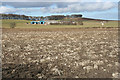
Fields below Boghead
The foreground is in this square, but a corner of another square lies between here and Boghead, which is thus two squares away.
Image: © Anne Burgess
Taken: 4 Mar 2015
0.04 miles
2
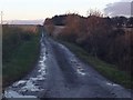
Farm road to Easter and Wester Mosshead
Image: © Steven Brown
Taken: 10 Nov 2013
0.10 miles
3
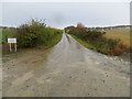
Hedge-lined farm track to Boghead
Looking north-westward.
Image: © Peter Wood
Taken: 26 Oct 2018
0.10 miles
4
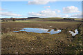
Waterlogged Ground
There has been very little rain recently, and no snow at all, yet the access to this field is full of water.
Image: © Anne Burgess
Taken: 4 Mar 2015
0.11 miles
5
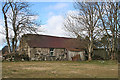
Tumbledown Cottage
The cottage, obviously uninabited though the grass has been kept under control, is beside some more modern houses opposite the track to Meikle Weistern.
Image: © Anne Burgess
Taken: 4 Mar 2015
0.13 miles
6
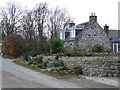
The Smiddy
Now a residentuial property, this house was formerly the village blacksmith's workshop.
Image: © James Allan
Taken: 30 Nov 2006
0.15 miles