IMAGES TAKEN NEAR TO
Forgue, HUNTLY, AB54 6DW
Introduction
This page details the photographs taken nearby to AB54 6DW by members of the Geograph project.
The Geograph project started in 2005 with the aim of publishing, organising and preserving representative images for every square kilometre of Great Britain, Ireland and the Isle of Man.

There are currently over 7.5m images from over14,400 individuals and you can help contribute to the project by visiting https://www.geograph.org.uk
Image Map
Images are licensed for reuse under creativecommons.org/licenses/by-sa/2.0
Notes
- Clicking on the map will re-center to the selected point.
- The higher the marker number, the further away the image location is from the centre of the postcode.
Image Listing (20 Images Found)
Images are licensed for reuse under creativecommons.org/licenses/by-sa/2.0
Image
Details
Distance
1
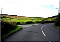
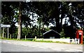
Conland Junction, Forgue
Access to Scott Hall and Forgue School, from B9001.
Image: © Stanley Howe
Taken: 20 Sep 2008
0.05 miles
2
The Scott Hall
This is the community hall in Forgue.
Image: © Anne Burgess
Taken: 9 May 2008
0.08 miles
3
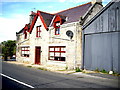
An eye-catching building in Forgue
By the B9001 near the bridge of the Forgue Burn. The plaque on the centre gable-end carries the initials JM with the date 1923. A viewer kindly informs me it used to be a village shop, known as 'The Emporium', but was closed some time ago and has more recently been sold on.
Image: © Stanley Howe
Taken: 20 Sep 2007
0.10 miles
4
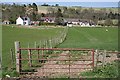
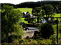
Forgue
These houses are clustered round the Bridge of Forgue, where the B9001 crosses the Burn of Forgue.
Image: © Anne Burgess
Taken: 9 May 2008
0.14 miles
5
Forgue Bridge
Viewed from Forgue kirkyard.
Image: © Stanley Howe
Taken: 20 Sep 2007
0.15 miles
6
Junction for Little Forgue
From B9001.
Image: © Stanley Howe
Taken: 20 Sep 2008
0.16 miles
7
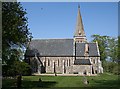
St Margaret's Church
Apart from a modest name plate saying that this is St Margaret's Church, there is no indication of what denomination it belongs to. I am indebted to Elspeth McKay-Smith who told me that it was an Episcopal Church, but has not been in regular use as a church since the 1960s. It is now owned by the estate, and is used occasionally for services such as weddings and funerals. The churchyard is still open for burials. An online search revealed that at least one funeral service was held there in 2007, and there are two graves with dates in 2008.
Image: © Anne Burgess
Taken: 9 May 2008
0.16 miles
8
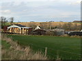
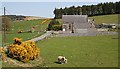
Little Forgue
Well stocked hay barn beside the Burn of Forgue.
Image: © James Allan
Taken: 30 Nov 2006
0.16 miles
9
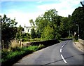
Forgue Bridge
Carrying B9001 over Forgue Burn, towards Huntly.
Image: © Stanley Howe
Taken: 20 Sep 2008
0.17 miles
10
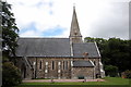
St Margaret's Episcopal Church, Forgue
Victorian Early-English with lancet windows from 1856. Looks like it was transported from Buckinghamshire...
Image: © Bill Harrison
Taken: 1 Jul 2017
0.17 miles