IMAGES TAKEN NEAR TO
Forgue, HUNTLY, AB54 6DU
Introduction
This page details the photographs taken nearby to AB54 6DU by members of the Geograph project.
The Geograph project started in 2005 with the aim of publishing, organising and preserving representative images for every square kilometre of Great Britain, Ireland and the Isle of Man.

There are currently over 7.5m images from over14,400 individuals and you can help contribute to the project by visiting https://www.geograph.org.uk
Image Map
Images are licensed for reuse under creativecommons.org/licenses/by-sa/2.0
Notes
- Clicking on the map will re-center to the selected point.
- The higher the marker number, the further away the image location is from the centre of the postcode.
Image Listing (4 Images Found)
Images are licensed for reuse under creativecommons.org/licenses/by-sa/2.0
Image
Details
Distance
1
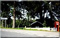
Junction for Little Forgue
From B9001.
Image: © Stanley Howe
Taken: 20 Sep 2008
0.06 miles
2
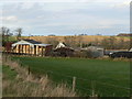
Little Forgue
Well stocked hay barn beside the Burn of Forgue.
Image: © James Allan
Taken: 30 Nov 2006
0.06 miles
3
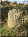
Old Milestone by the B9001, Forgue parish
Double bevel by the B9001, in parish of Forgue (Grampian District), East end of Little Forgue, 150m South of '40///' sign.
Inscription reads:-
AB
36
(To Aberdeen)
Surveyed
Milestone Society National ID: AD_ADIU36
Image: © Milestone Society
Taken: Unknown
0.12 miles
4
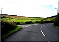
Conland Junction, Forgue
Access to Scott Hall and Forgue School, from B9001.
Image: © Stanley Howe
Taken: 20 Sep 2008
0.24 miles