IMAGES TAKEN NEAR TO
Inverkeithny, HUNTLY, AB54 6DL
Introduction
This page details the photographs taken nearby to AB54 6DL by members of the Geograph project.
The Geograph project started in 2005 with the aim of publishing, organising and preserving representative images for every square kilometre of Great Britain, Ireland and the Isle of Man.

There are currently over 7.5m images from over14,400 individuals and you can help contribute to the project by visiting https://www.geograph.org.uk
Image Map
Images are licensed for reuse under creativecommons.org/licenses/by-sa/2.0
Notes
- Clicking on the map will re-center to the selected point.
- The higher the marker number, the further away the image location is from the centre of the postcode.
Image Listing (5 Images Found)
Images are licensed for reuse under creativecommons.org/licenses/by-sa/2.0
Image
Details
Distance
1
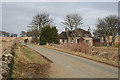
Charterstone
A horse and rider were the only other traffic on the minor road to Inverkeithny.
Image: © Anne Burgess
Taken: 27 Feb 2015
0.03 miles
2
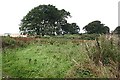
Waste Ground
There isn't any obvious reason why this patch of ground is neither cultivated nor forested.
Image: © Anne Burgess
Taken: 19 Sep 2008
0.21 miles
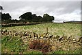
4
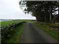
Drystane Dyke
The dyke follows the curve of the road round the corner of the field.
Image: © Anne Burgess
Taken: 19 Sep 2008
0.23 miles
5
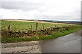
By the Road to Downies
Drystane dykes surround the fields here, though fences inside the walls now do the job of containing the livestock.
Image: © Anne Burgess
Taken: 19 Sep 2008
0.24 miles