IMAGES TAKEN NEAR TO
Inverkeithny, HUNTLY, AB54 6DJ
Introduction
This page details the photographs taken nearby to AB54 6DJ by members of the Geograph project.
The Geograph project started in 2005 with the aim of publishing, organising and preserving representative images for every square kilometre of Great Britain, Ireland and the Isle of Man.

There are currently over 7.5m images from over14,400 individuals and you can help contribute to the project by visiting https://www.geograph.org.uk
Image Map
Images are licensed for reuse under creativecommons.org/licenses/by-sa/2.0
Notes
- Clicking on the map will re-center to the selected point.
- The higher the marker number, the further away the image location is from the centre of the postcode.
Image Listing (4 Images Found)
Images are licensed for reuse under creativecommons.org/licenses/by-sa/2.0
Image
Details
Distance
1
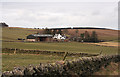
Downies Farm
Drystane dykes frame the view towards Downies Farm, with Boghead Hill in the background.
Image: © Anne Burgess
Taken: 27 Feb 2015
0.02 miles
2
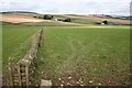
Downies and Ladybank
The dyke in the foreground seems to have been provided with barbed wire to protect it from cattle. Downies is the farm in line with the dyke, and Ladybank it to its right.
Image: © Anne Burgess
Taken: 19 Sep 2008
0.08 miles
3
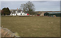
Ladybank Farm
Traditional farm house and steading north of the B9024.
Image: © Anne Burgess
Taken: 27 Feb 2015
0.11 miles
4
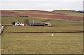
Ladybank
Looking north from the B9024, with Logg Hill in the distance.
Image: © Anne Burgess
Taken: 27 Feb 2015
0.13 miles