IMAGES TAKEN NEAR TO
Forgue, HUNTLY, AB54 6DE
Introduction
This page details the photographs taken nearby to AB54 6DE by members of the Geograph project.
The Geograph project started in 2005 with the aim of publishing, organising and preserving representative images for every square kilometre of Great Britain, Ireland and the Isle of Man.

There are currently over 7.5m images from over14,400 individuals and you can help contribute to the project by visiting https://www.geograph.org.uk
Image Map
Images are licensed for reuse under creativecommons.org/licenses/by-sa/2.0
Notes
- Clicking on the map will re-center to the selected point.
- The higher the marker number, the further away the image location is from the centre of the postcode.
Image Listing (4 Images Found)
Images are licensed for reuse under creativecommons.org/licenses/by-sa/2.0
Image
Details
Distance
1
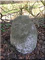
Old Milestone by the B9001, Drumblair Cottage, Forgue parish
Double bevel by the B9001, in parish of Forgue (Grampian District), South of Drumblair, opposite Drumblair Cottage.
Inscription reads:-
: 34 : : 18
(To Aberdeen and Inverurie)
Surveyed
Milestone Society National ID: AD_ADIU34
Image: © Milestone Society
Taken: Unknown
0.06 miles
2
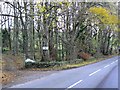
Drumblair Lodge
The entrance drive from the B9001.
Image: © James Allan
Taken: 30 Nov 2006
0.10 miles
3
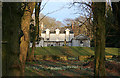
Drumblair Lodge
Formerly known as Drumblair Cottage, a name now applied to another house nearby, dates originally from 1780, but the twin advance wings were added in 1845. It stands back from the road but can be seen through the trees from the road. It is a Category B Listed building. The setting sun is just catching the upper windows.
Image: © Anne Burgess
Taken: 4 Mar 2015
0.12 miles
4
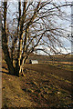
Paddock at Drumblair
This may or may not be a paddock, strictly speaking. I could not be certain as there were no animals in it.
Image: © Anne Burgess
Taken: 4 Mar 2015
0.18 miles