IMAGES TAKEN NEAR TO
Forgue, HUNTLY, AB54 6BX
Introduction
This page details the photographs taken nearby to AB54 6BX by members of the Geograph project.
The Geograph project started in 2005 with the aim of publishing, organising and preserving representative images for every square kilometre of Great Britain, Ireland and the Isle of Man.

There are currently over 7.5m images from over14,400 individuals and you can help contribute to the project by visiting https://www.geograph.org.uk
Image Map
Images are licensed for reuse under creativecommons.org/licenses/by-sa/2.0
Notes
- Clicking on the map will re-center to the selected point.
- The higher the marker number, the further away the image location is from the centre of the postcode.
Image Listing (4 Images Found)
Images are licensed for reuse under creativecommons.org/licenses/by-sa/2.0
Image
Details
Distance
1
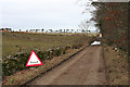
Flood
You could be forgiven for thinking that this is a farm road, but it is mapped as a public road.
Image: © Anne Burgess
Taken: 27 Feb 2015
0.15 miles
2
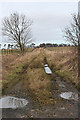
Track at Thorntown
Thorntown is shown on the map on the right here. The track used to lead to Newton of Auchingoul.
Image: © Anne Burgess
Taken: 27 Feb 2015
0.22 miles
3
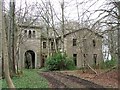
Haddo
Sad old Italianate mansion abandoned in the forest near to Inverkeithny.
Image: © C A Millar
Taken: 11 Apr 2005
0.23 miles
4
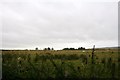
Muir Grazing
Cattle grazing at the aptly named Muirton.
Image: © Andrew Wood
Taken: 12 Sep 2011
0.25 miles